Tuesday, March 19, 2019

Inundation - Disaster in Nebraska

The last three days have been some of the "quietest" days, precipitation-wise, on the CoCoRaHS maps in almost two years. It's tragically ironic that on such quiet days a slow, widespread disaster is on-going from the central Plains to the Midwest.

Last week's huge and intense winter storm got a lot of attention due to the extremely high and in some cases record wind speeds measured, record low pressure, and widespread blizzard conditions. While that was big news at the time, the aftermath of this storm turned out to be more insidious and damaging than anything that occurred while the intense low pressure system was spinning over the U.S.

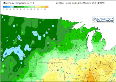
On the warm side of the storm, extending from Texas through the central Plains, warm most air was pulled northward by the strong circulation around the system. Temperatures in the 60s surged through Kansas and into southern Nebraska.


While the air was mild, there was still a lot of snow on the ground, and the soil underneath it was generally frozen.

Snow depth on March 11, 2019.
Credit: NOAA NOHRSC


4-inc soil temperatures under sod for the 24-hour period ending 3/13/2019.
Credit: MRCC Regional Mesonet Program
Rain fell on the warm side of the storm, with anywhere from one to three inches across Nebraska and southern South Dakota in a two-day period.


The mild air and heavy rain resulted in rapid snow melt. With the ground frozen, the water had no where to go except into rivers and streams. The snow across Nebraska held a water equivalent from one to more than two inches, so any runoff from the rain would have that much additional water from the melting snow.

Snow Water Equivalent (SWE) on March 11, 2019.
Credit: NOAA NOHRSC
The melting was rapid and considerable as the storm lifted to the northeast.

These maps show the snow melt for the 24-hour periods ending the mornings of March 13 and March 14. Snow melt was 2 inches per day or more.

By Friday, March 16 snow had disappeared from most of eastern Nebraska and western Iowa, draining into the rivers and streams.


The sudden surge of water running off from the precipitation and melting snow along with ice on the rivers began to compound the disaster. Water flowed from smaller streams into rivers and many then into the Missouri River. While the Missouri River has been getting attention, a number of smaller rivers in Nebraska reached major flood stage.


The Missouri River went from normal to record flood stage at Nebraska City and Plattsmouth in just 48 hours.

Hydrographs for the Missouri River at Omaha, Plattsmouth, and Nebraska City.
In addition to the flooding, huge chunks of ice that recently covered the rivers caused damage to bridges, roads, and fields. Whole towns have been cut off because of flooded or washed out roads. Farmers and ranchers are suffering devastating losses as fields are flooded and damaged by water and ice. Ranchers are having a difficult time feeding or even reaching their livestock, and many lost livestock to either the blizzard conditions or the flooding. An early estimate is that this disaster could result in a $400 million loss to the Nebraska livestock sector.

A comparison of eastern Nebraska in 2018 with no flooding (left) with 2019 (right).
Credit: NASA Earth Observatory
The National Weather Service Office in Valley, NE, west of Omaha and between the Platte and Elkhorn rivers had to be evacuated on Friday due to encroaching floodwaters from the rivers Operations were moved to Hastings, NE and forecasters will continue to work from there until floodwater recede and equipment can be checked and made operational. Almost 30 percent of Offutt Air Force Base near Omaha is flooded by the Missouri River. At it's closest extent the Air Force base is a little more than a mile from the river at normal stage.

Close-up view of the Omaha, NE area, 2018 and 2019.
Credit: NASA Earth Observatory
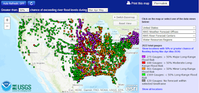
Even though river levels are slowly subsiding in Nebraska, recovery will be long and arduous. The northern Plains and central Midwest are continuing to deal with flooding conditions and it looks like flooding could be a big concern this spring in a large part of the country, particularly the central U.S. and the Northeast. This map shows where there is a greater than 50 percent chance of a flood risk from March through May.


The National Weather Service will be updating its Spring 2019 flood outlook on March 21. You can be sure there will be a lot of people closely paying attention.

Monday, March 11, 2019

Overview of February 2019 and Winter 2018-2019

How "bad" was the winter of 2018-2019? To be sure, winter is not yet over for some parts of the country no matter what the calendar says. As usual, though, how bad the winter was really depends on where you live.

February, the last month of climatological winter, was a cold one for the northwest half of the country, and very warm in the southeastern U.S. Montana experienced it's second coldest February on record as did North Dakota. Florida experienced its second warmest February on record.

February 2019 average temperature, departure from normal, and state ranking.

The cold across the northern tier was especially persistent. Great Falls, MT recorded nine days when the temperature didn’t rise above zero, and there were 23 nights when it dropped to zero or below. The longest stretch of subzero readings was 13 days, from February 3-15.The only days above freezing were February 1 and 2, when the high was 55°F and 49°F, respectively. The average February temperature in Great Falls was an astounding 27.5°F below normal!


The brutally cold weather continued into the first week of March, with a number of Montana locations setting all-time low temperature records for the month. Great Falls finally rose above freezing on March 7th for the first time in 32 days when the temperature reached a relatively balmy 36°F.

This was the second wettest February on record for the lower 48 states. Precipitation was much above normal in the much of the western U.S. west of the Rockies, the upper Midwest, and the Ohio and Tennessee Valleys. In the west, the only exception to the wet weather was an area from northwestern Oregon through much of Washington state. Tennessee recorded its wettest February on record. Many Tennessee CoCoRaHS observers reported double-digit precipitation totals during the month, with the highest 18.49 inches reported by the observer at Bells 2.5 NE in Crockett County (TN-CK-4).

February 2019 accumulated precipitation, percent of normal, and state rankings.
Speaking of being wet, the U.S. did record its wettest climatological winter in 125 years. It was also the wettest December-February in Tennessee. In terms of actual precipitation during the winter, the highest amounts were in California where a number of locations measured more than 50 inches. The California CoCoRaHS observer in Honeydew 3.2 SSE (Humboldt County, CA-HM-70) measured a whopping 89.84 inches, with more than half of that amount (45.14 inches) falling in February. 

Accumulated precipitation, percent of normal, and state ranks for December 2018-February 2019.

Winter temperatures were near to below normal across the northwestern half of the lower 48 states, and near to above normal across the southeastern half. The very cold weather in the northern Rockies and Plains in February was tempered by a warmer than normal December and January. The central and southern Plains and Midwest did endure several Arctic outbreaks, but they were generally short-lived.

Average temperature, departure from normal, and state ranks for the period December 2018-February 2019.

The snow season is far from over for many portions of the western U.S. (there is a reason the snow season runs from July 1 to June 30). As of the end of February, most of the U.S. had seen snow. Snow has been above normal from the central Plains through much of the northern Midwest, a small portion of the central Appalachians, and far northern New England. The Cascades and the Sierra Nevada were the big "winners", piling on the snow particularly in February. Some locations in northern California received more than 25 feet of snow in February alone.


At the end of February much of the southern half of the U.S. was without snow cover. Snow was still deep over the western mountains, the upper Great Lakes, and northern New England.


Additional details on the 2018-2019 snow season will be the subject of a future post.