Wednesday, May 29, 2013

Sloshing Into June

The last seven days have been a wet period from the Pacific Northwest to New England and for parts of Texas.  CoCoRaHS observers have been busy measuring inches of rain in many areas. The first map below shows the accumulated precipitation for the past seven days.  The second map shows the percent of normal precipitation.

Map compiled by the NWS Advanced Hydrologic Prediction Service

The greens to blue and violet colors depict normal to much above normal precipitation.
Map compiled by the NWS Advanced Hydrologic Prediction Service
The heavy rainfall, particularly in the Midwest, has been due to a frontal boundary that has extended from the western U.S. to the east coast. Since the weekend this boundary has been oscillating north and south as upper level waves have moved across the country. South of this boundary the air is warm and humid with dewpoints in the 60s. The warm humid air has fueled showers and thunderstorms along and north of the boundary.

Surface map for 7:00 a.m. CDT Tuesday, May 28, 2013
Over the next few days a much stronger upper level low will slowly move across the northern U.S.

500 millibar forecast map for 7:00 a.m. CDT Friday, May 31, 2013.

Heavy showers and thunderstorms are likely along this boundary once again, with from 2 to 4 inches of rain possible across the northern Plains and the Midwest.

Quantitative precipitation forecast for the 3-day period from 7:00 p.m. CDT May 29 to 7:00 p.m. CDT June 1, 2013.
This will prolong and worsen flooding along rivers in the Midwest. The Mississippi River from Burlington, Iowa south to St. Louis is mostly in moderate flooding at the present time, but with the expected rainfall the river is forecast to be in major flood during the first week of June at most river gauges along that reach.

 This map shows the Maximum Forecast Flood Category through June 7, 2013. 0


Sunday, May 26, 2013

More Unusual May Weather

The road to Whiteface Mountain
on Saturday, May 25th.
This weekend saw another round of unusual weather at opposite sides of the country. In NewEngland, a remarkable spring storm dropped 24 to 34 inches of snow in upstate New York on Whiteface Mountain at an elevation of 4867 feet. A strong low pressure system moving through the northeast brought several days of heavy precipitation to northern New York and western Vermont. Precipitation totals for the past six days range from 5 to 9 inches, with the heavier amounts in Vermont. On Saturday the rain mixed with and changed to snow in northern New York and Vermont, with snow accumulating at elevations above 900 feet. Snowfall in Vermont ranged from 1.0 inch at Richford, VT to 18.0 inches at Jay Peak, VT (elevation 3862 feet). Some ski areas were reportedly open for the weekend thanks to the snow.


There was deluge amidst drought this weekend in Texas. Thunderstorms dropped more than a foot of rain on the San Antonio, TX metropolitan area.  Some thunderstorms occurred during the afternoon Saturday, but heaviest rain fell in training nocturnal thunderstorms late Saturday night to early Sunday morning. Here is the CoCoRaHS map for Saturday, May 25 for Bexar County.  San Antonio is located near the center.


The heavy rain caused flash flooding in the San Antonio area, with some streams approach record high flood levels. A new record flood stage was set on the San Antonio River Saturday morning.

River stage observations for the San Antonio River

The rain is sorely need in Texas, where lake and reservoir levels are very low from two years of drought. However, this was definitely too much too fast.  Unfortunately the flash flooding caused three fatalities, caused a roof of an apartment complex to collapse, and inundated many roads.

Monday, May 20, 2013

Moore, Oklahoma Tornado

The 12-month period from May 2012 through April 2013 tallied the  fewest number of tornadoes for a 12-month period since 1954.  There were only seven people killed in that 12 month period, the fewest since 1899. The unusually cool spring weather has been responsible for suppressing the severe weather this year. The switch seemed to be flipped about the middle of this month, however.  On May 15 an EF-4 tornado struck Granbury, Texas north of Dallas and an EF-3 hit Cleburne in Johnson County. There have been tornadoes reported on every day since, with 30 tornado reports yesterday, and so far 15 today.

This afternoon one of those tornadoes swept through Moore, Oklahoma, a southern suburb of Oklahoma City. This was a massive, devastating tornado. I watched it on radar and on a live television feed out of Oklahoma City. It was scary to see even though I was hundreds of miles away.  The tornado was at least a mile wide and was on the ground for about 20 miles (all of these numbers are preliminary until a survey can be completed). However, the most stunning realization that came to mind is that this is Moore's second encounter with a catastrophic tornado. On May 3, 1999 a massive tornado, rated F5 with winds in excess of 300 mph, struck Moore, killing 44 people, causing 581 injuries, and $1 billion in damages. Since May 1999 the residents of  Moore have had other encounters with tornadoes, but none the magnitude of today's tornado.

Tracks of the May 3, 1999 and May 20, 2013 Moore tornadoes.
Compiled by the National Weather Service Oklahoma City.

Here is a video of today's tornado as it moved through Moore.

As I write this there are already 51 confirmed fatalities from today's tornado. Rescuers continue to search for survivors in one of three schools that were hit by the tornado. Whole neighborhoods are unrecognizable.  The National Weather Service has preliminarily rated this tornado as an EF-4, but numbers don't convey the anguish of the families of those who lost their lives or the devastation to property that this community has experienced. There are a number of active CoCoRaHS observers in Moore and we hope they and their families are safe.

This tornado was well-warned. The tornado was on the ground for about 40 minutes, and a tornado warning was issued 16 minutes before the tornado developed.  I was astounded to hear people being interviewed state that they didn't know a tornado was approaching. It drives home the fact that no matter how soon warnings are issued, all of us have some personal responsibility to make sure we are aware of what is going on. Do you have a weather radio?  Every home and business should have one! There are smart phone apps that will alert you to severe weather wherever you are. The pendulum may be swinging back on this severe weather season. Make sure you are prepared.

Thursday, May 16, 2013

April Recap - Cold, Snowy, Wet, and Dry

The weather during April 2013 was, in so many words, all over the place. Record cold and snow dominated the north-central U.S. Record rainfall and colder than normal weather plagued the central U.S., delaying spring planting and causing major flooding. Dry weather in the southwestern U.S got drier and drought conditions worsened there. April was also drier than normal in the northeastern U.S.


Here are some April statistics from the National Climatic Data Center. Some of these are preliminary and may change as new data arrives and is tabulated.

  • North Dakota had its coldest April on record, 9.9°F below average.
  • South Dakota, Nebraska, Kansas, Oklahoma, Minnesota, and Wisconsin each had a top ten cold April.
  • It was the 7th coldest April on record for Alaska.
  • Approximately 3,430 record low temperatures and about 4,050 record cold daily high temperatures were tied or broken. In comparison, approximately 690 record warm daily high temperature records and 1,570 record warm daily low temperatures were tied or broken. (These numbers are preliminary and are expected to change as more data arrive.)
  • Duluth, MN had its snowiest month on record with 50.8 inches of snow, breaking the old record of 50.1 set in November1991. The previous record for the snowiest April was 30.6 inches in 1950.
  • The April snow cover extent in the U.S. was the 5th largest on record.
  • The April average precipitation for the contiguous U.S. tied with 1953 as the 19th wettest April on record.
  • Iowa and Michigan both had their wettest April on record.
  • Tennessee, Illinois, Indiana, and Wisconsin each had one of the ten wettest Aprils on record.
  • While drought conditions improved in the central U.S., they worsened in the southwestern U.S. California experienced its driest January-April on record with only 27% of average precipitation. Snowpack in the Sierra Nevada was only 18% of normal.

Here is how the states ranked for temperature and precipitation.


You can read more about the April weather on the National Climatic Data Center's State of the Climate National Overview page, including narratives of regional highlights provided by the Regional Climate Centers.

Wednesday, May 8, 2013

Lumbering Low Lingers

The major upper level trough that brought snow to the Rockies, Midwest and as far south as Arkansas the first two days of the month is still producing rainfall in the eastern U.S. a week later.

The trough developed a closed circulation on May 3 and the closed low has been slowly, very slowly, making its way east through the southern half of the country.

Animation of the 7:00 a.m. CDT 500 millibar map for May 2-7, 2013

This morning the upper low was centered over northern Virginia and was responsible for more than two inches of rain in the mid-Atlantic region in the past 24 hours.


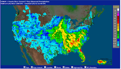
The path of this system can be seen in both the precipitation and temperature patterns for the past 7 days.  Precipitation from the Plains through the southeastern U.S. has been much above above normal as you might expect. The persistent cloudy, rainy, and cool weather has significantly delayed spring planting.

Total 7-day precipitation ending the morning of May 8, 2013.
Map from the NWS Advanced Hydrologic Prediction Service.
The low's progress across the country can also be discerned from the temperature departures over the last week.  Temperatures were much below normal along the storm's path. The ridge of high pressure over the northeastern U.S. kept temperatures much above normal from the Great Lakes through New England. Temperatures were also warmer than average along the west coast and in the Pacific Northwest where a high pressure ridge was also situated.


The closed low will continue moving northeast the next two days, and will finally dissipate as it moves off of the New England coast on Friday.


Thursday, May 2, 2013

Heavy Snow, Heavy Rain, and Wildfire

It was another eventful weather day across the country, and not in the way you would normally picture the second day of May. The storm that brought snow to an area from the Rockies to northwestern Wisconsin continued to crawl eastward today, leaving a lot of records in its wake. A trough along the central Gulf brought 5 to more than 10 inches of rain to southwestern Alabama and southeastern Mississippi. Dry, warm, and windy weather prompted red flag warnings for southern California and other portions of the southwest U.S.

As of this morning a surprising 10 to 15 inches of snow was on the ground from southeastern Minnesota through northwestern Wisconsin, and accumulating snow continued in Wisconsin during the day.


Map prepared by the NWS Duluth office
As you might imagine, May snowfall records toppled with this storm. The NWS Cooperative Observer in Dodge Center MN (Dodge County) reported 15.4 inches of snow in the 24-hour period ending at 7:00 a.m. CDT this morning. If verified, this would be a new daily snowfall state record for May in Minnesota breaking the old record of 12 inches set on three previous dates, the most recent on May 3, 1954 near Leonard, MN.  Daily snowfall records were set at many locations in the storm-affected area in Iowa, Minnesota, and Wisconsin.

You can read more about the record snow in Minnesota and Wisconsin at the following NWS office web pages:

National Weather Service, Duluth MN
National Weather Service, LaCrosse, WI

In Omaha, NE the snow on May 1 and May 2 set daily records on both dates.  The combined total of 3.1 inches for May 1-2, 2013, is a record snowfall event in May as well as a record highest monthly snowfall total ever recorded in May.  In Lincoln, NE May 1 snowfall was 2.4 inches on May 1 and 0.2 for today (May 2), both daily records.  Kansas City, MO set new daily snowfall records on both May 1 and May 2.  The combined total of 3.1 inches for May 1-2, 2013, is a record snowfall event in May as well as a record highest monthly snowfall total ever recorded in May. 

This storm was clearly evident in the temperature pattern across the U.S. today, reflecting the strong upper level trough.


500 millibar (about 20,000 ft) upper level map for 7:00 p.m. CDT May 2

Surface temperatures at 7:00 p/m/ CDT May 2

The upper level ridge over the western U.S. was providing sunny and very dry weather. In California these conditions along with the Santa Anna winds combined to produce critical fire wildfire conditions in southern California, southern Nevada, and central Arizona. Red flag warnings were in effect for most of these areas today.

Fire weather outlook for May 2 issued by the NWS Storm Prediction Center
A wildfire in the Los Angeles area that initially was confined to about 10 acres this afternoon grew rapidly to 6,500 acres by late afternoon and as of this post is about 8,000 acres. A second wildfire was burning east of Los Angeles in Riverside County.

A slow-moving low pressure system along the central Gulf coast was brought up to a foot of rain to extreme southwest Alabama near Mobile and southeastern Louisiana.

CoCoRaHS rainfall map for May 2
Thunderstorms continued today, and more heavy rain is possible overnight.

Wednesday, May 1, 2013

A Crazy Start to May

Here it is, the last month of spring, when most are anxiously await the unofficial start of summer  in four weeks.  However, winter is hanging on by its fingernails in the central and western U.S. and the cool spring continues over much of the country.

Snow today in Fort Collins, CO.
Photo by Zach Schwalbe
Winter weather in May is not unusual in the Rockies, but it is in the central Plains and Midwest. Cold air remains entrenched over the northern U.S.  The lowest temperature in the nation this morning was 9°F at Denton Montana. Even late this afternoon, temperatures were in the 30s from Wyoming and Colorado, across Nebraska and northeast through Minnesota.  Heavy, wet snow began last night and continued falling in the Front Range much of the day, and this afternoon began spreading across Nebraska. By late afternoon several inches of snow were on the ground in Grand Island in central Nebraska. By this evening snow was falling from eastern Nebraska through northwestern Iowa northeast to Minneapolis. Two days ago temperatures were in the mid 80s in the southeastern half of Nebraska and in the low 80s as far north as Minneapolis!

Surface map at 4:00 p.m. CDT May 1

South and east of the low pressure center and ahead of the very strong cold front, severe storms developed in Oklahoma and Texas with a number of reports of quarter to golf ball size hail. Note the huge temperature gradient across new Mexico and the panhandle of Texas. At the time of this map (6:00 p.m. CDT) temperatures ranged from 39°F at Clayton, NM in the northeast corner of the state to 91°F at Carlsbad in the southeast corner of New Mexico.  Winds behind the cold front were north at 20-30 mph gusting to 45 mph.

Surface temperatures at 6:00 p.m. CDT May 1
The high temperature in the nation today was 101°F at Dryden, Texas (just inside the 95 degree contour on the map). Most of the southeastern half of the country enjoyed warm spring temperatures this first day of May. Much of this same area enjoyed sunny weather as well, with the exception of portions of the Gulf coast and Florida where showers and thunderstorms occurred.

The weather will be turning cooler and wetter in the Midwest and east over the next several days, but that's another story.