The trough developed a closed circulation on May 3 and the closed low has been slowly, very slowly, making its way east through the southern half of the country.
 |
| Animation of the 7:00 a.m. CDT 500 millibar map for May 2-7, 2013 |
This morning the upper low was centered over northern Virginia and was responsible for more than two inches of rain in the mid-Atlantic region in the past 24 hours.
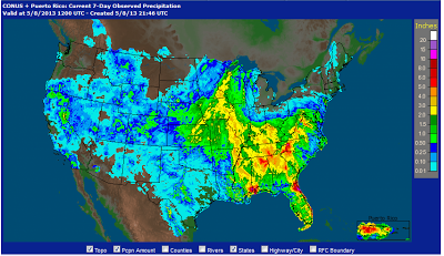
The path of this system can be seen in both the precipitation and temperature patterns for the past 7 days. Precipitation from the Plains through the southeastern U.S. has been much above above normal as you might expect. The persistent cloudy, rainy, and cool weather has significantly delayed spring planting.
 |
| Total 7-day precipitation ending the morning of May 8, 2013. Map from the NWS Advanced Hydrologic Prediction Service. |
The closed low will continue moving northeast the next two days, and will finally dissipate as it moves off of the New England coast on Friday.


No comments:
Post a Comment