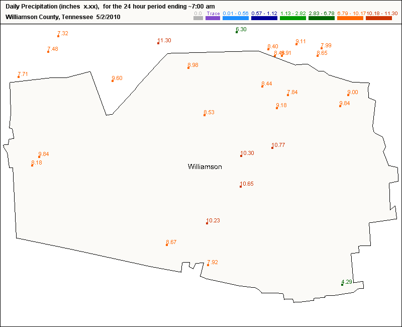
You can pull a map like this for any county, any state on the CoCoRaHS web site.
Much of middle Tennessee saw anywhere from 10 to 18 inches of rainfall in a 2-day span over the weekend, breaking all kinds of records and causing widespread flooding.
Another area hard-hit by heavy rain was the greater Memphis area, especially on the northside. If you take the Danny Thomas Blvd. (Hwy 51) north into Tipton County you drive through the city of Millington - where some levees were breached - causing widespread flooding across that area.
Thank goodness for the detail of CoCoRaHS - without it, the only reports we would have during heavy rain events like this one are the main first order weather stations from the area, such as Memphis and Nashville, and then any co-op stations in the area.
We certainly would not have as many reports per county as we have like in the example above.
It was a deadly weekend across the south, with lives not only taken from flood waters, but also from twisters. Arkansas was hard-hit 2 days in a row with over a dozen tornadoes reported - leaving several injured and at least 1 dead.
Mississippi saw another deadly twister for the second weekend in a row - this time a little north and east of Yazoo City.
No comments:
Post a Comment