 The most recent storm is now out to sea, but as it crossed the U.S. the last three days it left a blanket of snow and ice in its wake. On Sunday snow, sleet, and freezing rain fell across the Midwest and Ohio Valley, with upwards of 7 to 8 inches in the Missouri Ozarks. On Monday two to six inches of snow covered the ground from southeastern Ohio through northern Virginia and southern New Jersey. Today snow fell from southern Minnesota and Iowa across southern Wisconsin and northern Illinois.
Earlier this week subzero low temperatures covered the northern Midwest and Great Lakes.
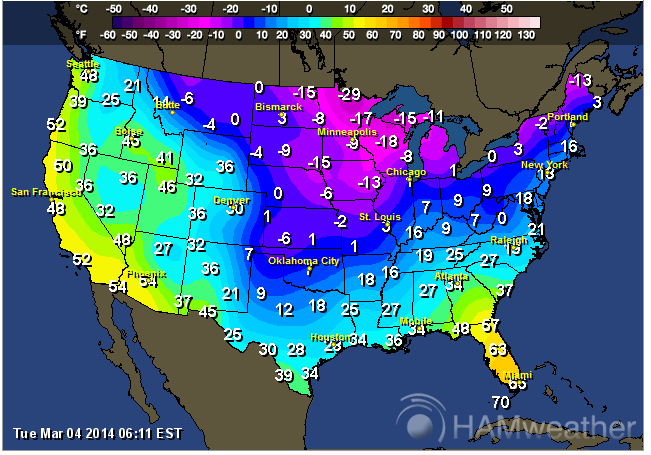 |
| Minimum temperatures for Monday, March 3, 2014 |
A little over 51 percent of the lower 48 states had snow on the ground as of this morning.

The final numbers on meteorological winter are still being tallied by the National Climatic Data Center and will be available in a few days. However, we already know the this winter will be in the record books for one reason or another. Detroit, MI is experiencing one of its most severe winters on record and has piled up 83.8 inches of snow this season so far, a little less than 10 inches short of the all time record of 9.6 inches in 1880-1881. Out of the 92 days in meteorological winter, Embarrass, MN recorded 32 days with a minimum temperature of -30°F or lower (yes, you read that correctly), a new state record for Minnesota, and through today there have been 10 days with -40°F or lower. The average temperature for the winter was -5.5°F.
 |
| Daily maximum and minimum temperatures for Embarrass, MN from December 1, 2013 to March 5, 2014 |
In the east snowfall in Philadelphia at the end of February at 59.5 inches, 40.5 inches above normal (with another 3.4 inches since then). New York City snowfall totaled 57.3 inches at the end of February, 36 inches above normal.
Here is an neat animation of the cold air outbreaks over the U.S. for January through February. This was produced by.the Computational & Information Systems Laboratory at the National Center for Atmospheric Research in Boulder, CO. The maps depict surface air temperatures, which are measured at a height of 2 meters (about 6 feet) above ground level.
While the eastern half of the U.S. has been dealing with brutal winter conditions, the western U.S. and Alaska have been unusually warm. Anchorage experienced its 15th warmest winter on record. In contrast to snowfall in the Midwest and east, Anchorage snowfall was at 53.4 inches at the end of February, almost 7 inches below normal. The Iditarod Sled Race from Anchorage to Nome (about 1,000 miles) has been hampered this year by snowless trail conditions. The lack of snow and rough trails have already knocked 11 mushers out of the race. The race began on March 2nd.
I would like to see that "neat animation"!
ReplyDeleteSorry, DRat - somehow it disappeared between the time I inserted into the post and when I finally posted. It's there now.
ReplyDeleteMajor cool (no pun intended)! Thanks!
ReplyDelete