 |
| This image shows large portions U.S. 34 washed away at the mouth of the Big Thompson canyon |
While a large area has been affected by flooding, Boulder, Colorado was the epicenter for the heaviest rain. Here are some climatological facts for Boulder rainfall to help place this in perspective
Boulder's annual precipitation averages 20.68 inches, with an average of 1.68 inches in September.
For September 1-13, the U.S. Cooperative Weather Station in Boulder has received 14.74 inches of rain. This nearly three times the previous monthly September record of 5.50 inches in 1940! This is also the wettest month ever on record for Boulder. The previous record was 9.59 inches in July 1995.
Much of Colorado has been in severe drought or worse for more than a year, and Boulder and much of the area was on track for another very dry year. Through the end of August, Boulder's precipitation for the year was 12.96 inches, which placed it in the top 30 percent of driest years in Boulder.
With the precipitation through September 13th, the total precipitation for the year so far is 27.70 inches, which now makes this year the second wettest on record. The wettest year on record is 1995 with 29.43 inches. There is no question that 2013 will eclipse this mark - the only questions are by how much and when.
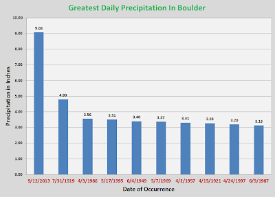
Not only did the rainfall so far this month destroy the previous monthly record, but the 9.08 inches recorded on September 12 shattered the precious record of 4.80 inches measured on July 31, 1919..
 |
| Source: National Weather Service Denver/Boulder |
While the U.S. Cooperative station in Boulder is the official record, rainfall totals measured by CoCoRaHS observers were just as if not more impressive. Here are the rainfall totals of 10 inches or more for the period September 9-14.
| Station No. | Station Name | Total Precip | # of Reports |
| CO-BO-33 | Boulder 3.3 SE | 18.36 | 6 |
| CO-BO-72 | Boulder 1.3 NW | 15.45 | 6 |
| CO-BO-299 | Boulder 3.0 S | 15.29 | 5 |
| CO-BO-9 | Boulder 1.4 NNW | 15.05 | 6 |
| CO-BO-4 | Boulder 2.9 S | 14.79 | 6 |
| CO-BO-35 | Boulder 1.5 NW | 14.75 | 6 |
| CO-BO-14 | Boulder 1.6 S | 14.71 | 5 |
| CO-BO-286 | Boulder 3.5 S | 14.56 | 6 |
| CO-BO-321 | Boulder 1.7 S | 14.13 | 5 |
| CO-BO-337 | Boulder 1.6 NW | 14.06 | 5 |
| CO-LR-907 | Livermore 10.6 W | 13.95 | 4 |
| CO-BO-288 | Boulder 0.5 NNE | 13.88 | 6 |
| CO-BO-120 | Boulder 3.0 E | 13.80 | 4 |
| CO-AD-127 | Aurora 4.2 NNW | 13.74 | 6 |
| CO-BO-74 | Boulder 5 SE | 13.72 | 5 |
| CO-AD-170 | Aurora 4.5 NW | 13.13 | 5 |
| CO-BO-234 | Louisville 2.5 NW | 13.01 | 5 |
| CO-BO-282 | Boulder 4.4 S | 12.99 | 5 |
| CO-BO-164 | Boulder 3.0 NNW | 12.79 | 6 |
| CO-BO-230 | Boulder 6.8 WNW | 12.28 | 5 |
| CO-BO-219 | Riverside 2.2 NE | 12.15 | 3 |
| CO-AR-55 | Aurora 2.9 NW | 12.11 | 4 |
| CO-BO-349 | Boulder 1.2 N | 12.10 | 3 |
| CO-BO-67 | Boulder 4.7 E | 12.00 | 5 |
| CO-BO-243 | Louisville 2.6 WSW | 11.91 | 5 |
| CO-BO-202 | Ward 4.6 NE | 11.67 | 6 |
| CO-AR-99 | Aurora 4.1 S | 11.42 | 6 |
| CO-BO-135 | Boulder 5.4 ESE | 11.13 | 6 |
| CO-DN-183 | Denver 5.1 ENE | 11.08 | 5 |
| CO-JF-365 | Golden 2.1 SW | 10.99 | 6 |
| CO-AR-270 | Aurora 0.7 WSW | 10.80 | 6 |
| CO-AR-262 | Aurora 2.1 W | 10.78 | 6 |
| CO-LR-749 | Drake 4.7 SSE | 10.68 | 3 |
| CO-AR-281 | Aurora 2.4 SW | 10.62 | 5 |
| CO-LR-882 | Loveland 12.2 W | 10.54 | 6 |
| CO-BO-19 | Boulder 4.6 E | 10.45 | 5 |
| CO-JF-63 | Golden 4.8 NW | 10.39 | 6 |
| CO-JF-279 | Pinecliffe 3.1 ESE | 10.27 | 5 |
| CO-LR-866 | Estes Park 2.2 S | 10.05 | 6 |
| CO-AR-264 | Aurora 3.8 S | 10.03 | 6 |
 |
| Forecast surface map for 12 noon MDT Sunday, September 15 |
 |
| Quantitative Precipitation Forecast for the 48-hour period ending 6:00 p.m. MDT Monday, September 16. |

No comments:
Post a Comment