Monday, May 17, 2010

Week Ahead: Continued Active

On the map below, I have drawn two large purple circles around the main weather stories we'll be looking at this week.


#1 - the stalled front over the Ohio River Valley in the southeast. Showers and thunderstorms are in the forecast today from St. Louis to Washington DC. This is the same upper-level storm system that sat over the central Rockies last week bringing day after day of inclement weather to places like Colorado.

The southern end of that disturbed area is a little cold front over north Texas and Louisiana. This will be the focal point for isolated severe thunderstorms later today.

#2 - a new storm system is moving on shore in the Pacific Northwest today and it will spread showers and thunderstorms with some mountain snow into Washington and Oregon, as well as the northern half of California. It will spread into the central and northern Rockies for the middle of the work week. BY Wednesday, it will spawn some severe weather in the central plains states.


Think It's Been Wet?


The map below shows the total accumulated precipitation for the last 7 days across the nation - it's been a wet one for many! With few exceptions - just about the entire lower 48 states have seen measurable precipitation.


And it has been a rather cool spring thus far for many of us. Here in Denver, we are running almost 8 degrees cooler than average so far this May! Other cooler-than-normal locations thus far in May include...

  • Phoenix, Arizona - 2 degrees cooler than average

  • Pendleton, Oregon - 3 degrees cooler than average

  • Bismarck, North Dakota - 8 degrees cooler than average

  • Grand Rapids, Michigan - 1 degree cooler than average

  • Waterloo, Iowa - 4 degrees cooler than average

  • Oklahoma City, Oklahoma - 2 degrees cooler than average

    Places from Atlanta, Georgia to Burlington, Vermont are running about 1 to 2 degrees ABOVE normal thus far this May.


  • Saturday, May 15, 2010

    Texas Rains - Holy Buckets!

    Texas received widespread heavy rain on Friday - with daily rainfall records set in several cities - including Houston, Galveston and Midland.

    This morning, heavy rain has been falling in Victoria, Texas.

    It prompted an alert to be issued that I have never seen before on the National Weather Service maps. It was called a "Shelter In Place" warning. Here is the text.

    MANY STREETS ACROSS THE COUNTY OF VICTORIA HAVE BEEN INUNDATED WITH


    FLASH FLOODING. THE EMERGENCY MANAGEMENT COORDINATOR HAS REQUESTED

    THAT RESIDENTS OF VICTORIA COUNTY STAY AT HOME DURING THE MORNING

    HOURS OF MAY 15TH 2010 DUE MANY STREETS ARE IMPASSABLE. THIS

    MORNING...EMERGENCY SERVICES ARE OVERWHELMED WITH HIGH WATER

    RESCUES.

    Friday, May 14, 2010

    Nashville Flooding Video

    Look at this amazing video as flood waters rush into a retail store in the Nashville area during the recent flood event.

    Watch Flood Video Here

    We all have heard about the power of water, and for many, have either witnessed or maybe even personally experienced it.

    This is video confirmation of it!

    Thursday, May 13, 2010

    Hurricane Season Days Away

    This Saturday marks the beginning of hurricane season for the Eastern Pacific Ocean. Forecasters will be watching the waters off the west coast of Mexico for any signs of tropical storm formation.

    Shortly thereafter, on June 1, the hurricane season gets underway for the Atlantic Basin, which includes the Gulf of Mexico and the Carribbean Sea.

    The National Hurricane Center has made some changes to their products for the upcoming season, one of the biggest is they will be adding 12 hours of additional lead time to all watches and warnings that are issued.

    Another change is to the actual advisory products issued to the public. They will now be organized into sections and will use bullet points and lists to highlight important information - letting the eye quickly identify keywords and find specific information quickly.

    There will also be some changes to the "forecast cone" as well as some new experimental forecast products.

    Click here to read a full listing of these changes and additions!

    Wednesday, May 12, 2010

    Here We Snow Again

    Well below are some pictures from traffic cameras around the Denver metro. Most of the city saw 1 to 3 inches with some 3 to 6 inch totals in the higher suburbs and up north toward Wyoming.


    Tuesday, May 11, 2010

    This is a great radar from the Denver area around 10 pm Tuesday. Snow, rain, thunderstorms - you got it all with a good spring storm in the Rockies!

    Currently getting thundersnow at my house!

    50-Degree Spread

    If you drove US Highway 287 today from Larimie, Wyoming to Amarillo, Texas - you woud encounter a 50-degree difference in temperatures.

    As I write this blog temperatures are in the middle to upper 30s across southeast Wyoming while they are in the upper 80s across the Texas panhandle.

    Colorado is the battle ground with the largest temperature spread from north to south. I have a map below with Highway 287 outlined and the boundaries of the two airmasses.


    Monday was a deadly day in Oklahoma as severe thunderstorms with strong tornadoes moved through the center of the state.

    I am sure you have all heard the amazing survival stories on the news.

    A new tornado watch has just been issued for southwest Oklahoma for the threat of thunderstorms with possible tornadoes as we head into the evening hours.

    Oklahoma City is on the extreme eastern edge of this watch box - so residents should keep abreast of the latest.

    Monday, May 10, 2010

    Spring & Winter Storms

    While much of Kansas and Oklahoma will be under the gun today for severe storms with high winds and large hail - and possibly long-track tornadoes - in and around Denver - we are preparing for a late season winter storm.

    Areas just south and west of Denver are under a watch for the potential to see several inches of heavy, wet snow.

    In the city of Denver, we are expecting a rain and snow mix with maybe a few inches on the grassy surfaces.

    This will unfold more as we get into the day on Tuesday - just who sees what and when. One model went crazy with snow totals of 25 to 50 inches in the foothills west of Denver. That'd be one heck of a weather headline if it happened this late in the year!

    But for now - let's focus on Kansas and Oklahoma - and the surrounding areas - as they will be under the gun  for a potentially rough evening of weather.

    If the tornadoes do form - they will target the more populated areas between Wichita, KS and Tulsa, OK - so keep on alert today in this part of the world.

    Saturday, May 8, 2010

    Lotta Wind, Lotta Cold

    Well the severe weather event I blogged about yesterday came to fruition - BUT - it wasn't as intense as some forecasters feared it could be.

    There were plenty of severe thunderstorm warnings and even some tornado warnings - and there were some reports of damage - but all in all - not too bad.

    Here is a map of the severe weather reports from Friday.

    Another weather story we're following today is the cold temperatures in the northern and central Rockies and the across the plains states.

    Just look at all the cold weather advisories in blue on the map below!

    Snow has been flying across the Dakotas, Minnesota and Montana with the cold air - in fact- Duluth, Minnesota picked up one of their largest May snowfalls ever with nearly 5 inches!

    Friday, May 7, 2010

    Moderate Risk For Storms Today, Will It Compare To 1985 Tornado Outbreak?

    The Storms Prediction Center is forecasting a moderate risk of severe weather across northern Ohio, northwest Pennsylvania, northeast Indiana and southwest upstate New York. I would also include portions of southern Ontario, Canada in that threat area too.

    The Weather Channel's Dr. Greg Forbes has given this region a 60% chance of a tornado on his TORCON index.  SEE MORE HERE

    Ironically, this same region saw a huge tornado outbreak in May of 1985 that killed a total of 88 people - 65 of which were in Pennsylvania.

    The setting for the storms today is a warm front draped across the region along with an area of low pressure that will deepen and drag a cold front across the area later today. This setup is similar to the set up in 1985.

    I was reading the forecast discussion for that region and forecasters were talking about a cap in the atmosphere and dry air in place. This may delay the outbreak of severe weather, but it may also result in the formation of well developed supercells, giving the storms more time to rotate.

    Hopefully - if we do see a tornado event today - it won't be deadly. My hunch is that this part of the world isn't as used to tornado outbreaks as people in the south or plains states - so many were caught off guard or didn't have a tornado action plan in 1985. Not to mention it was 1985 and technology and forecasting has come a long way since then.


    But if you live in this part of the world or have friends and family there - just take a little extra time today to think of what you will do in the event you find yourself facing a tornadic storm. Or call your friends and family and ask them to do the same.

    REMEMBER: lowest level of the structure you are in, and hopefully in an interior room away from doors and windows. PROTECT YOUR HEAD! (either be under sturdy furniture, or use a mattress or pillow) This is key - flying debris is what often kills people during a tornado.
    Forecasters look for backing winds with height during a severe weather outbreak and we definitely have that in place today across the region at risk.

    The picture below is a Skew-T diagram from Detroit this morning. It is drawn as the daily weather balloon goes up and collects data. Look at the far right and you will see the wind vectors.

    At the bottom right, we have southeast winds at the surface, but as you go up in height, they become south, then southwesterly. This is called backing.

    Another thing forecasters look for when trying to deterine if conditions are right for a large-scale tornado outbreak is shear - that is a difference in speed as the winds back - going from slower to faster with height.

    Right now it isn't a huge difference, although a little shear is present. I am sure by the afternoon balloon release this will change as the storm system evolves throughout the day.


    If you are curious to learn more about the large and deadly tornado outbreak on May 31, 1985 - CLICK HERE.

    Thursday, May 6, 2010

    New Storm Shelter Ahead Of Next Outbreak

    The long range forecast models paint a very active week coming up - with some cold air moving into the lower 48 states early next week.

    The air is cold enough that one model I saw has rain and snow for the Denver area by next Wednesday if you can believe that one!

    I can - the average May snowfall in Denver is 1.3 inches!

    Along with that cold air will come the chance for a severe weather outbreak in the central and southern plains. The Storms Prediction Center says the way things look right now, the stage could be set for storms with significant tornadoes on Monday, May 10 - across western and central Kansas, Oklahoma, and northern Texas.

    The map below shows the threat area.


    It is a pretty safe bet to say that next week will be active after a fairly quiet Mother's Day weekend coming up. How active? Well - those details will unfold in the days to come.

    And speaking of storms - a friend of mine in Arkansas just had a storm shelter installed in her yard after years of close calls and seeking safety from passing thunderstorms.

    This past weekend - Arkansas was the focus of a pretty significant tornado outbreak with over a dozen reported touchdowns that left a lot of damage, several injuries and even one death.

    As a native of Arkansas - storms can be just plain scary. You can get a lot of nighttime tornadoes in the south - and those are the most dangerous - not to mention the most scary.

    Here are some pictures of her new storm shelter!


    The first picture is the storm shelter being delivered. The second is after the shelter is placed in the ground.She writes that she is really happy with the new shelter! It is guaranteed not to leak for 10 years!
    The shelter is made of 1/4 inch steel and concrete and has 3 steps going down that are covered with carpet. There is also carpeting on the benches and the floor inside.

    The state of Arkansas has a rebate program for those interested in getting a storm shelter installed. You can get $1,000 or 50% of the cost back, whichever is less.


    And if you are not in Arkansas, but live in another tornado prone state, check with your office of emergency management to see if there might be a similar program in your state.

    My aunt, who also lives in Arkansas, had a safe room installed in her house. The closet of her master bedroom is completely surrounded by a steel frame, cinder bock and I believe some type of additional reinforcing - and instead of a normal closet door - it has a big, heavy steel door. So in the event of a tornado, this is where they seek shelter.

    If you can't afford a storm shelter at this time, please consider at least having a NOAA weather radio. They are affordable and can be purchased online or at selected retailers, like Radio Shack.

    This radio is connected to the National Weather Service. It has an alarm you can set that will sound whenever any type of weather watch or warning is issued for your area.

    You will get the alert at the exact same time the media outlets get their data - and while most television and radio stations react quickly - those 1 or 2 minutes of additional lead time could just be the window you need to seek safety in your home or office.

    NOAA weather radios come in all shapes and sizes and are battery operated. Here is a link to several models starting at just $24.95 plus shipping!


    Winter Not Finished Yet


    And as we talk about cold air moving into the country next week - we are already dealing with the first wave of cold air. Heavy snow is in the forecast for portions of the Dakotas!!!


    Wednesday, May 5, 2010

    Tornado In Wisconsin, Deserts Heating Up

    Tuesday brought some severe weather to portions of the northern tier of US states, including a tornado touchdown near the town of Clayton in east-central Wisconsin.

    The event was short-lived but did cause damage to some homes along Grandview Road near Winchester.

    Two homes were especially hard-hit, including one of a local firefighter. Can you imagine hearing the page for help and it is your own address?

    Thankfully, there were no injuries.

    In the northeast - there were dozens of reports of severe weather from upstate New York to the coast of Massachusettes.

    The majority of the reports were high wind gusts in excess of 60 MPH - including a gust of 63 in Syracuse. A few locations saw hail in excess of 1 inch in diameter - including Ithica,  NY.

    Here in Colorado - we had several reports of wind damage as strong downslope winds developed along the  Front Range.

    Some locations along the foothills of Boulder and Jefferson Counties - including the towns of Boulder and Lyons - saw winds gust between 75 and 105 MPH. There were a handful of damage reports.

    The strong winds fueled a wildfire in southern Jefferson County near the town of Conifer which prompted the evacuation of over 300 homes.


    And things are finally heating up in the deserts of the southwest! Temperatures in both Phoenix and Las Vegas will climb into the 90s today.

    It has been a cool start to the warm season. We usually see the daily highs in the 90s start sometime in early to mid April. And while there have been a few 90-degree days so far, nothing like normal.

    The average high in Phoenix was only 82.5 degrees during the month of April - in Yuma it was 81.9 degrees. Normal for both cities is around 85 degrees.

    Click here for much more on average temperatures in southern Arizona.

    Tuesday, May 4, 2010

    Impressive Middle Tennessee Rain Recap

    The National Weather Service office in Nashville has made a contour map of the recent weekend deluge - using several data sources, including your CoCoRaHS reports.

    You can see the whole region saw heavy rain - but there were a few bullseyes of the heaviest precip - such as over the greater Nashville area. And the largest totals came from Benton County, Tennessee - just west of Nashville - with 19 to 20 inches!


    Below is the web link to see the full size image from the Nashville office of the National Weather Service.

    Link to image above: Click here

    Monday, May 3, 2010

    CoCoRaHS Reveals Storm's Footprint Across Tennessee

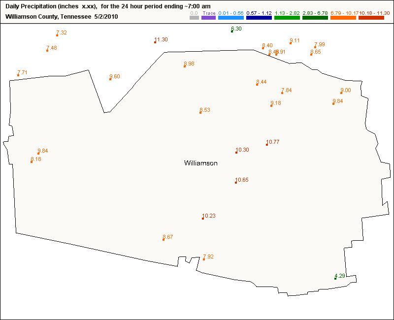
    Below is a map of Williamson County, Tennessee - it shows the 24 hour rainfall totals ending 7 am on May 2, 2010.

    You can pull a map like this for any county, any state on the CoCoRaHS web site.

    Much of middle Tennessee saw anywhere from 10 to 18 inches of rainfall in a 2-day span over the weekend, breaking all kinds of records and causing widespread flooding.

    Williamson County is just south of the Nashville vicinity.

    Another area hard-hit by heavy rain was the greater Memphis area, especially on the northside. If you take the Danny Thomas Blvd. (Hwy 51) north into Tipton County you drive through the city of Millington - where some levees were breached - causing widespread flooding across that area.

    Thank goodness for the detail of CoCoRaHS - without it, the only reports we would have during heavy rain events like this one are the main first order weather stations from the area, such as Memphis and Nashville, and then any co-op stations in the area.

    We certainly would not have as many reports per county as we have like in the example above.

    It was a deadly weekend across the south, with lives not only taken from flood waters, but also from twisters. Arkansas was hard-hit 2 days in a row with over a dozen tornadoes reported - leaving several injured and at least 1 dead.

    Mississippi saw another deadly twister for the second weekend in a row - this time a little north and east of Yazoo City.

    Saturday, May 1, 2010

    More Deadly Tornadoes Possible

    Friday brought a severe weather outbreak to the center of the nation - with tornadoes and severe thunderstorms reported from Wisconsin to Texas.

    Hardest hit was the state of Arkansas with over a dozen reports of twisters.

    Central Arkansas took the worst of it with at least one tornado proving to be deadly.

    The storm prediction center has issued another high risk area for severe weather today - extending from central Arkansas into western Tennesseee and northern Mississippi.