December 1st marked the start of meteorological winter, and winter got off to an early start and persisted through the month and into the new year in the central and eastern portions of the country.
December temperatures were below normal for most of the western two-thirds of the country. The only area consistently above normal was from the Ohio River Valley
through the mid-Atlantic and southeastern U.S. Temperatures averaged
from 12 to 15 degrees below normal from the northern plains into
northern Minnesota, and more than 5 degrees below normal in the central
and southern plains.
There were a few breaks from the cold weather,
particularly in the southern and eastern portions of the central U.S.
The breaks were short-lived, though, thanks to an upper level wind
pattern that funneled cold air out of the Arctic and into the U.S.
 |
| Mean 500 millibar pattern for December 2013. The white arrows depict the direction of the wind flow. |
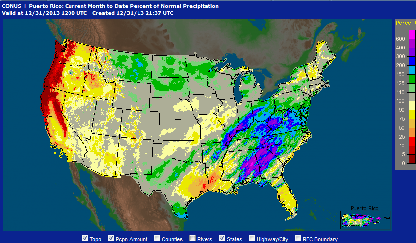
December precipitation was heavy in the Ohio Valley and in the central and southern Appalachians. It was very dry in northern California northward through Oregon and Washington. A lot of the precipitation in the northern and central U.S. fell as snow, and at the end of December snow cover was deep across much of Canada and extended southward through the northern tier of the U.S. Of significance is the "snow drought" in the Sierra Nevada in California. Snow pack is only 11 percent of normal in the northern Sierra to about 30 percent of nromal in the southern Sierra.
 |
| Percent of normal precipitation for December 2013. |
 |
| Snow depth (in centimeters) across Canada and the U.S. as of January 1, 2014. |
In the near term cold, snowy weather is in the cards for the central and eastern U.S. The eastern U.S. will get short break after the current nor'easter heads out to sea late on Friday. However, another system developing ahead of the next Arctic outbreak will bring snow to the Midwest beginning late Saturday and Sunday and the Northeast late Sunday and Monday. It will be followed by some the coldest air the Midwest and East have seen in the past few years.
 |
| Forecast high temperatures for Monday, January 6, 2014 |


No comments:
Post a Comment