
Meanwhile, the rain doesn't seem to want to stop in the Gulf States and the Southeast. Until recently a strong upper low rotating over southeastern Canada kept the jet stream pushed further south than usual for summer, bringing cool dry weather to the central U.S.
 |
| The 500 millibar map (~20,000 ft) on Sunday, August 18. A trough persists over the eastern half of the country, though much weaker than earlier in the week |
 |
| Surface map for 7:00 CDT Sunday, August 18. |
The persistence of this pattern is readily seen in an animation of the daily CoCoRaHS maps for the last seven days.
 |
| CoCoRaHS precipitation maps for 8/14 through 8/20/2013 |
Precip through All time wettest
8/19
Asheville, NC 58.62 64.91 1973
Roanoke, VA 41.52 58.87 1948
Macon, GA 55.79 67.80 (1929)
For both Asheville and Macon it's really not a question of if the records will be broken, but when. Roanoke's precipitation is currently 17.35 inches from the record. Normal precipitation for September through December is 13.12 inches, so higher than normal precipitation will be needed there to break the record. An interesting note about Asheville's rainfall -the 2013 rainfall total represents the largest departure from normal out of 180 cities reviewed in a recent study by the National Climatic Data Center (coincidentally located in Asheville). The current total pf 58.62 inches is 31.41 inches above normal.
The are a number of locations in the western Carolinas with precipitation for the year-to-date in excess of 80 inches. Here are precipitation accumulations over 80 inches recorded by CoCoRaHS observers in the southeast. These are stations that had at least 95 percent of possible days reported from January 1-August 20.
SC-PC-4 Cleveland 8.0 WSW 89.15
NC-WT-10 Blowing Rock 2.2 NE 86.82
NC-AV-9 Linville 2.5 ENE 83.00
NC-WT-1 Blowing Rock 22.8 ENE 81.31
More rain is on tap for the southeast for this week with an inch or two additional rain from northern Georgia through the western Carolinas and northward into West Virginia. Dry weather will continue across much of the central U.S., although a cold front will likely produce scattered showers and thunderstorms across the northern Midwest.
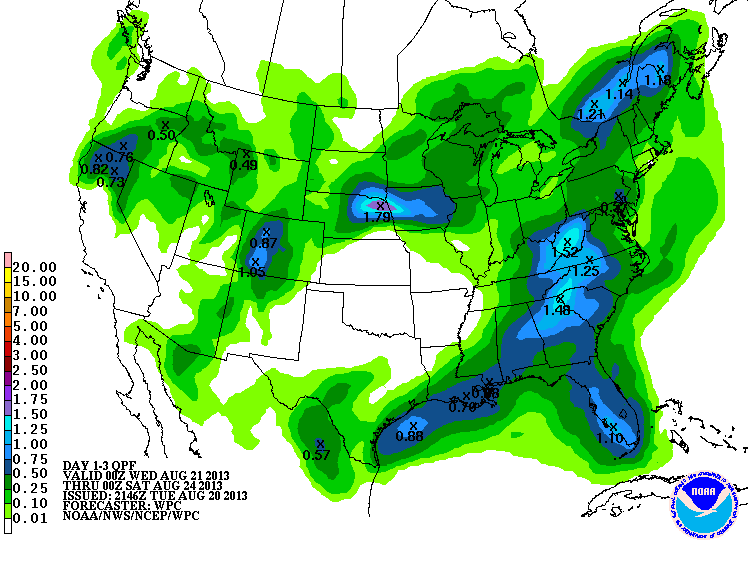 |
| 72-hour Quantitative Precipitation Forecast for the period ending 7:00 p.m. CDT Friday, August 23 |
No comments:
Post a Comment