Monday, July 9, 2012

How Dry I Am...

That loud sound this weekend was that of the heat wave breaking in the eastern half of the U.S.  After days of triple digit record high temperatures in many locations, the upper level ridge shifted west and allowed cooler air to spill south into the nation’s midsection behind a relatively weak cold front. That is the good news. The bad news is that although there were some showers and thunderstorms associated with the front, there were not nearly enough to break the expanding and intensifying drought that grips much of the country.

The map on the left is the 500 millibar map upper air map (about 18000 to 20000 feet up) for the morning July 6 showing the upper level ridge planted over the middle of the country. The map on the right shows the 500 millibar map for this morning.  The axis of the ridge has retreated to the west, and cooler air from Canada is flowing into the central and eastern U.S.
 The July 3rd U.S. Drought Monitor depicted an astounding 76 percent of the lower 48 states in Abnormal Dryness, and 36 percent in Severe Drought or worse.  This is a critical time for agriculture in the corn and soybean belt, as corn is in or approaching the pollination stage. The lack of water and the heat will take a toll on corn yields, and grain prices are already rising as the condition of the crop worsens.  Soybeans can tolerate more heat and have some more time before they reach a critical period of development in August.

In an ironic twist, the High Park fire area west of Fort Collins, CO received two to four inches of rain this weekend, resulting in flash flooding. Debris from the fire was washing into piles creating debris dams, further exacerbating the flooding.  Two weeks ago firefighters were dealing with the wildfire. This weekend they were pumping basements flooded by the rain.

With drought so dominant at this time, we need and appreciate your daily rainfall reports, especially those reports of ZERO. The spotty nature of showers and thunderstorms mean that some locations can receive inches of rain, while a few miles away there's not enough to settle the dust.  

Davidson County, TN rainfall for the morning of July 9, 2012.  Nashville is located near the red dot.
 "0.00" is a measurement- it explicitly states that you measured no rain. No report, on the other hand, leaves everyone guessing.  There have been an impressive number of CoCoRaHS observers regularly reporting rainfall, zero and otherwise.  Below is the map from June 26 when the central U.S. was dry as a bone.

On June 26 there were 9,561 total reports, of which 7,061 were zeroes (gray dots).


So remember, "Be a Hero - Report Your Zero!"

Friday, July 6, 2012

The Catch - Important request at a critical time of year

Dear CoCoRaHS rain gauge team
 
A belated 4th of July greeting.  It was odd here to have no fireworks 
show last night (I know the same was true in many other areas of the 
country).  But it simply was not appropriate given the severity of heat, 
drought and wildfire potential.  There were scarcely any backyard 
firecrackers, either -- a clear sign of public recognition of the 
situation.   Nevertheless, we were able to celebrate with friends and 
family some of what makes this such a great country.  I, for one,  gave 
thanks that we live in a country where so many people love to volunteer 
their time and resources to accomplish important things together.  Our 
mutual rain gauge program (CoCoRaHS) is one small example of that.
 
 
We need more rainfall data
 
We are currently experiencing extreme heat, extreme drought, extreme 
storms, and local floods in various parts of the country.  In all my 
years in this field, there have only been a few others where there was 
this much public, media and commercial interest and concern over 
precipitation (or lack thereof) in so many parts of the country.
 
 
Does it really matter?
 
Yes indeed!  Our CoCoRaHS rainfall reports are a huge and valued 
resource to weather and water forecasters, agribusinesses, researchers, 
teachers, resource managers and many more.  We already have great 
volunteers all over the country, but rainfall varies so much that we 
still aren't tracking it well in many places.  We need more gauges in 
more places.
 
Look at today's (July 5) maps http://www.cocorahs.org/Maps/ In Wake County, NC precipitation ranged from 0 to over 3" in just a few miles. Likewise, check out Pima County, AZ (0.05" - 4.32"), Real County, TX (0.19" - 3.74"), Pasco County, FL (0 - 2.95") and Oakland County, MI (0.13" - 2.03") We were able to pinpoint these remarkable local variations because we were fortunate to have many volunteers in each of those counties. For much of the country we only have one or two reports per county. Despite good progress this year, we still have a few hundred counties nationally with no active reporters. And now is when it matters most. This is the time when rainfall is most locally variable -- and this is the time when drought is having the most acute impacts over the largest areas. It is also the time when the most intense rains tend to fall -- from localized summer thunderstorms. As I write, I am recalling 15 years ago (can't believe that much time has passed already) when we had 14" of rain right here in Fort Collins -- but other parts of town had less than 2". If we had volunteers then reporting their rainfall and sending in "Significant Weather Reports" during the heaviest rains, there is some chance we might have helped saved lives that night. This same situation repeats itself every year but in different places. Our rainfall reports really can make a difference. You can help. Here are some ideas and suggestions 1) Many of us are already helping. Thank you so much for checking your gauge and sending in your reports. Please know, your efforts are appreciated. Also know that the earlier in the day you submit your report (ideally by 9 AM), then the more weather and water forecasters will be able to use your data -- both when it rains and when it doesn't. We're working on smart phone data entry that will make this easier for some of you. 2) Some of us signed up but have never gotten started. If this sounds like you, PLEASE begin now. This alone could add several thousand new observers to the network and that would be AWESOME. It's really easy (at least in summer). If you have questions or need help getting started, just send a quick e-mail to info@cocorahs.org or contact the local CoCoRaHS volunteer leader (coordinator) for your area listed here: http://www.cocorahs.org/Content.aspx?page=coord If you were very interested in reporting rainfall but could not join CoCoRaHS because of the ~$30 cost of the rain gauge, please let me know. We have some generous sponsors who are helping in these situations. 3) A whole lot of us signed up, got started, but didn't stick with it for a whole variety of good reasons. If this sounds like you == then please consider trying again. It really only takes a couple of minutes a day -- and we're very flexible (report when you are able, and don't worry about it when you're away or too busy). 4) Help recruit new volunteers! -- Tell your friends and family, especially those who live in areas where we have few volunteers. Ask with some urgency and say things like "CoCoRaHS really needs your help" -- If you have contacts at local newspapers, magazines or TV stations, see if they would put out a story about CoCoRaHS and how local citizens can help. -- If belong to organizations such as Rotary or Lions clubs, Master Gardeners, Master Naturalists, Conservation Districts, Watershed Stewards, Amateur Radio, and any of a large number of similar organizations, tell them about CoCoRaHS and invite others to join. Spread the word however you can. -- Make use of the CoCoRaHS short animation to quickly describe who we are and what we do http://youtu.be/M5-sXXg9M30 -- If you want to give more history about how CoCoRaHS started, then view this slightly longer video http://youtu.be/yHmz5IyjV80 5) Many of us have had to retire from CoCoRaHS. Thanks, and we hope you elect to continue to be a part of our family even if you can't take measurements any longer. Other CoCoRaHS News The Blog is back http://cocorahs.blogspot.com/ The CoCoRaHS water cycle animation is a hit.
View the Water Cycle video here.
Have you tried CoCoRaHS Facebook? http://www.facebook.com/CoCoRaHS Farm News -- Good and sad Despite the heat and drought, we're getting a decent crop of apples from our early tree. The apples (and it's always been this way) like to fall off the tree about a week before they are ready to pick or eat. But if we get them before they're too bruised, they make a fine apple sauce. The last couple of weeks the tree has been full of Flickers -- a flock of them. I never knew that flickers flocked, but we've been told they were driven out by the fire in the foothills and have been congregating at local water holes (like our tree). I don't now if this is true, but it sounds good. Our goslings are growing up so fast -- fun to watch at this stage of life. Despite the heat, the chickens are still laying quite well -- plenty of fresh eggs/ Several of you have asked about Angel (our beautiful female Great Pyrenees who added many stories to our lives these past few years). There's been so much going on and I just haven't felt like talking about it. She left this world a few weeks ago -- hopefully for greener pastures. My plan to show a picture of us together and recount a few good memories in the CoCoRaHS Blog soon. In closing Nice little thunderstorm this evening -- not enough to make a flood or end a drought, but for now the air is fresh and cool -- a great relief after many days of heat. Thanks for your interest in CoCoRaHS. It's a pleasure working with all of you. Sincerely, Nolan Doesken Colorado State University

Wednesday, July 4, 2012

Hotter Than a Firecracker


Much of the nation will be experiencing hot, humid summer weather on this Fourth of July.  Maximum temperatures will exceed 90°F in most locations east of the Rockies, and many locations in the nation’s midsection will see temperatures in excess of 100°F. 

Forecast maximum temperature for July 4, 2012

 
At 11:00 a.m. EDT the Midwest and mid-Atlantic region from Delaware to South Carolina were already at 85°F and higher, and the dewpoint ranged from 65° to greater than 70°F. 

Temperature (L) and dewpoint (R) at 11:00 EDT July 4, 2012
The heat index (apparent temperature) represents what it really feels like when humidity is factored in with the actual air temperature. The heat index today could reach close to 110°F in many locations – anything 105°F or higher is dangerous.  Excessive heat warnings and heat advisories have been issued for much of the Midwest, parts of the mid-Atlantic, and in western Alabama.

Forecast heat index for 5:00 p.m. EDT July 4, 2012
Heat advisories (orange) and excessive heat warnings (pink) are in effect for most of the central U.S.

On a day when picnics, parades, and fireworks are tradition, the danger posed by the heat and humidity is very real. Believe it or not, heat is the number one weather-related killer in the United States, resulting in hundreds of fatalities each year.

If you are going to be outside during hot weather know how to stay safe, and learn the warning signs of heat cramps, heat exhaustion, and heat stroke.  Information on heat waves and how to cope with them can be found at the following links:


Have a safe and happy 4th of July, everyone!

Sunday, July 1, 2012

Derecho Plows through Eastern U.S.


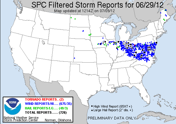
Trees were uprooted, homes and businesses were damaged, and millions of people were without power in the wake of a derecho event on Friday, June 29. 

If you haven’t heard this term before, a derecho is a widespread, long-lived wind storm that is associated with a band of rapidly moving showers or thunderstorms, with the damage typically directed in one direction along a relatively straight swath. By definition, if the wind damage swath extends more than 240 miles and includes wind gusts of at least 58 mph or greater along most of its length, then the event may be classified as a derecho.  The event on June 29 met these criteria, and then some.

The derecho began as morning thunderstorms moved out of the Chicago area and into northwestern Indiana, where warm and very unstable air was present. The first severe thunderstorm watch was issued just before noon EDT for northeastern Illinois and the northern half of Indiana. Three more severe thunderstorm watches were issued during the day and night from Ohio to the mid-Atlantic coast.

By the time the storms moved out into the Atlantic about 2:00 a.m. EDT Saturday, an estimated 4 million people were without power, 3 million in the mid-Atlantic region alone. More than 660,000 were left without power in Ohio, and 188,00 in Indiana. In Ft. Wayne, Indiana, 95 percent of the distribution circuits were knocked out by the storms. There were ten fatalities attributed to the storms.

This image of the progression of the derecho is courtesy of NOAA's NWS Storm Prediction Center.


Follow this link to view a video of radar images along the path of the derecho as it progressed east.

At the time of this writing more than 600 reports of damaging winds had been logged for the derecho.  


Some of the more impressive reports:

Wind Gust (knots/mph)
Location


91/105
Fort Wayne, IN airport
87/100
Wintergreen, VA
84/97
Paulding, OH
81/93
Roanoke, VA airport
81/93
Tuckerton, NJ
80/92
Dayton, OH airport
80/92
Franklin, WV
80/92
Fredericksburg, VA


CoCoRaHS observers submitted 29 Significant Weather Reports on Friday. No doubt the time of the storms in the east (late at night) along with power and Internet outages cut down on the number of reports.  Here is a report from one CoCoRaHS observer in Ohio:

Station Number: OH-FR-24
Station Name: Columbus 9.3 NNE
Date: 6/29/2012 4:00 PM
Submitted 6/30/2012 6:40 AM
Notes: Very High winds with a thunderstorm est. at 80 MPH gusts 6-8 inch limbs down in my area, In the metro area large outdoor advertising signs folded in two like it was slammed into. Never seen damage like this before 

People affected by the storms not only have to cope with the damage, but they are suffering  through oppressive heat and humidity without air conditioning. High temperatures on Saturday were in the low to upper 90s throughout the storm-impacted areas. The heat wave is expected to continue through the week, and officials think it could be the end of the week before most power is restored in Maryland and Virginia.

You can read more about derechos at the Storm Prediction Center web site.

Origin and Evolution of the Term “Derecho” as a Severe Weather Event


Sunday, April 1, 2012

Very cool wind map

Click here to see a very cool map of the dominant wind patterns around the US. This link was shared by someone on a weather chat board I subscribe to on Facebook.

New tornado warnings carry "unsurvivable" message

Have you read about this?

The new tornado warnings that will carry a pretty intense message?  They aim to scare.

Click here to read