Wednesday, July 4, 2012

Hotter Than a Firecracker


Much of the nation will be experiencing hot, humid summer weather on this Fourth of July.  Maximum temperatures will exceed 90°F in most locations east of the Rockies, and many locations in the nation’s midsection will see temperatures in excess of 100°F. 

Forecast maximum temperature for July 4, 2012

 
At 11:00 a.m. EDT the Midwest and mid-Atlantic region from Delaware to South Carolina were already at 85°F and higher, and the dewpoint ranged from 65° to greater than 70°F. 

Temperature (L) and dewpoint (R) at 11:00 EDT July 4, 2012
The heat index (apparent temperature) represents what it really feels like when humidity is factored in with the actual air temperature. The heat index today could reach close to 110°F in many locations – anything 105°F or higher is dangerous.  Excessive heat warnings and heat advisories have been issued for much of the Midwest, parts of the mid-Atlantic, and in western Alabama.

Forecast heat index for 5:00 p.m. EDT July 4, 2012
Heat advisories (orange) and excessive heat warnings (pink) are in effect for most of the central U.S.

On a day when picnics, parades, and fireworks are tradition, the danger posed by the heat and humidity is very real. Believe it or not, heat is the number one weather-related killer in the United States, resulting in hundreds of fatalities each year.

If you are going to be outside during hot weather know how to stay safe, and learn the warning signs of heat cramps, heat exhaustion, and heat stroke.  Information on heat waves and how to cope with them can be found at the following links:


Have a safe and happy 4th of July, everyone!

Sunday, July 1, 2012

Derecho Plows through Eastern U.S.


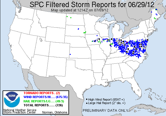
Trees were uprooted, homes and businesses were damaged, and millions of people were without power in the wake of a derecho event on Friday, June 29. 

If you haven’t heard this term before, a derecho is a widespread, long-lived wind storm that is associated with a band of rapidly moving showers or thunderstorms, with the damage typically directed in one direction along a relatively straight swath. By definition, if the wind damage swath extends more than 240 miles and includes wind gusts of at least 58 mph or greater along most of its length, then the event may be classified as a derecho.  The event on June 29 met these criteria, and then some.

The derecho began as morning thunderstorms moved out of the Chicago area and into northwestern Indiana, where warm and very unstable air was present. The first severe thunderstorm watch was issued just before noon EDT for northeastern Illinois and the northern half of Indiana. Three more severe thunderstorm watches were issued during the day and night from Ohio to the mid-Atlantic coast.

By the time the storms moved out into the Atlantic about 2:00 a.m. EDT Saturday, an estimated 4 million people were without power, 3 million in the mid-Atlantic region alone. More than 660,000 were left without power in Ohio, and 188,00 in Indiana. In Ft. Wayne, Indiana, 95 percent of the distribution circuits were knocked out by the storms. There were ten fatalities attributed to the storms.

This image of the progression of the derecho is courtesy of NOAA's NWS Storm Prediction Center.


Follow this link to view a video of radar images along the path of the derecho as it progressed east.

At the time of this writing more than 600 reports of damaging winds had been logged for the derecho.  


Some of the more impressive reports:

Wind Gust (knots/mph)
Location


91/105
Fort Wayne, IN airport
87/100
Wintergreen, VA
84/97
Paulding, OH
81/93
Roanoke, VA airport
81/93
Tuckerton, NJ
80/92
Dayton, OH airport
80/92
Franklin, WV
80/92
Fredericksburg, VA


CoCoRaHS observers submitted 29 Significant Weather Reports on Friday. No doubt the time of the storms in the east (late at night) along with power and Internet outages cut down on the number of reports.  Here is a report from one CoCoRaHS observer in Ohio:

Station Number: OH-FR-24
Station Name: Columbus 9.3 NNE
Date: 6/29/2012 4:00 PM
Submitted 6/30/2012 6:40 AM
Notes: Very High winds with a thunderstorm est. at 80 MPH gusts 6-8 inch limbs down in my area, In the metro area large outdoor advertising signs folded in two like it was slammed into. Never seen damage like this before 

People affected by the storms not only have to cope with the damage, but they are suffering  through oppressive heat and humidity without air conditioning. High temperatures on Saturday were in the low to upper 90s throughout the storm-impacted areas. The heat wave is expected to continue through the week, and officials think it could be the end of the week before most power is restored in Maryland and Virginia.

You can read more about derechos at the Storm Prediction Center web site.

Origin and Evolution of the Term “Derecho” as a Severe Weather Event


Sunday, April 1, 2012

Very cool wind map

Click here to see a very cool map of the dominant wind patterns around the US. This link was shared by someone on a weather chat board I subscribe to on Facebook.

New tornado warnings carry "unsurvivable" message

Have you read about this?

The new tornado warnings that will carry a pretty intense message?  They aim to scare.

Click here to read

Sunday, March 18, 2012

Stormy days ahead

Take a look at how colorful the weather map is today with plenty of watches, advisories and warnings.

In the west it's for snow across the higher mountains in the central and southern Rockies. East of the mountains the threat is for near hurricane force winds and high fire danger from west Texas to the plains of western and central North Dakota.

Severe thunderstorms are expected to develop later today across the southern and central plains states. There is the threat for strong and damaging tornadoes in a few areas. Sadly, this threat will roll east over the next few days.


Another threat is for extremely heavy rain totals in the Ozarks and nearby areas. Some long range models show 5 to 10 inches during the week ahead with a bullseye across western Arkansas.

Monday, March 12, 2012

Flash flood emergency in Louisiana

An isolated pocket of extremely heavy rain has fallen across a portion of south-central Louisiana over the past 36 hours, causing life-threatening flash flooding.

Here is the latest.

FLASH FLOOD STATEMENT


NATIONAL WEATHER SERVICE LAKE CHARLES LA

1157 AM CDT MON MAR 12 2012


...FLASH FLOOD WARNING REMAINS IN EFFECT FOR NORTHWESTERN ST.


MARTIN...NORTHEASTERN ACADIA...NORTHERN LAFAYETTE AND SOUTHERN ST.

LANDRY PARISHES UNTIL 530 PM CDT...


...A FLASH FLOOD EMERGENCY FOR NORTHERN LAFAYETTE AND SOUTHERN ST.

LANDRY PARISHES...


RAINFALL AMOUNTS BETWEEN 10 AND 15 INCHES HAVE BEEN ESTIMATED ACROSS

THE WARNED AREA AND ADDITIONAL RAINS CONTINUE TO FALL.


AT 1155 AM...LOCAL LAW ENFORCEMENT OFFICIALS AND EMERGENCY

MANAGEMENT REPORTED FLOODING WITH NUMEROUS ROADS AND HOMES FLOODED.

IN ADDITION SEVERAL HIGH WATER RESCUES ARE UNDERWAY. THIS IS A RARE

EVENT AND MAY CAUSE SOME LOCATIONS LIKE BAYOU VERMILION AT CARENCRO

TO REACH RECORD FLOODING. MANY ROADS ARE CLOSED AND YOU SHOULD NOT

TRAVEL IN THIS AREA TODAY.

Sunday, March 11, 2012

Historic storm slams Hawaii


Hawaii has not exactly been the tropical paradise it's known for over the past several days.

A rare tornado with very large hail struck Lanikai and Enchanted Lakes. See the public information statement for the National Weather Service below.

Hail was up to 3 inches in diameter, something very rare for this part of the world.

...EF-0 TORNADO STRIKES LANIKAI AND ENCHANTED LAKES...

BACKGROUND...
THE NATIONAL WEATHER SERVICE OFFICE IN HONOLULU DISPATCHED A
DAMAGE SURVEY TEAM TO INVESTIGATE A STRING OF WIND RELATED DAMAGE
FROM THE ENCHANTED LAKES AREA OF KAILUA TO LANIKAI ON THE ISLAND
OF OAHU. THE SURVEY TEAM INSPECTED THE WIND RELATED DAMAGE AND
INTERVIEWED HOMEOWNERS AND OTHER EYEWITNESSES AND SOUGHT TO
DETERMINE WHETHER THE DAMAGE WAS RELATED TO A TORNADO OR STRAIGHT
LINE WINDS.

FINDINGS...
EYEWITNESS ACCOUNTS...PHOTO AND VIDEO EVIDENCE...AND DAMAGE
PATTERNS INDICATED THAT A WATERSPOUT VERY LIKELY MOVED ASHORE IN
LANIKAI AND TRAVELED INLAND BEFORE DISSIPATING IN THE ENCHANTED
LAKES SUBDIVISIONH. UPON MOVING ASHORE...THE WATERSPOUT BECOMES
CLASSIFIED AS A TORNADO. THUS...THE DAMAGE SURVEY TEAM HAS
DETERMINED A TORNADO FORMED AND TRACKED BETWEEN LANIKAI AND
ENCHANTED LAKES. THE CIRCULATION VERY LIKELY LIFTED AND THEN
RETURNED TO THE SURFACE AS IT TRAVERSED AN AREA OF HIGHER TERRAIN
BETWEEN LANIKAI AND THE ENCHANTED LAKES AREA...AND PERHAPS LATER
IN THE ENCHANTED LAKES SUBDIVISION.

TORNADO STATISTICS...
STRENGTH...EF-0 WITH WIND SPEEDS OF 60-70 MPH
AVERAGE WIDTH...20 YARDS
PATH LENGTH...1.5 MILES


The region also experienced several days of VERY heavy rain, with some locations 
recording as much as 45 inches!!!
 
Below is the public information statement on the heavy rain event.
 
...TORRENTIAL RAINS SLAM HAWAII IN THE PAST WEEK...

A SLOW MOVING FRONT BROUGHT HEAVY RAIN TO MOST ISLANDS THE PAST 
WEEK...AS IT INTERACTED WITH SEVERAL DISTURBANCES ALOFT. THE 
FOLLOWING REPRESENTS 7-DAY RAINFALL TOTALS...FROM 11 AM FRIDAY MARCH 
2 THROUGH 11 AM FRIDAY MARCH 9. 

THESE PRELIMINARY TOTALS WERE CALCULATED USING PROVISIONAL REPORTS
FROM AUTOMATED RAIN GAGES THAT HAVE NOT BEEN QUALITY CONTROLLED.

LOCATION                                      AMOUNT

KAUAI
/HNIH1/ HANALEI                                45.97
/WNHH1/ WAINIHA POWER HOUSE                    43.84
/KPIH1/ KAPAHI                                 32.66
/WLLH1/ MOUNT WAIALEALE RAINGAGE               31.32
/WLDH1/ WAILUA DITCH - USGS                    28.23
/KLOH1/ KILOHANA RG - USGS                     26.88
/WUHH1/ WAILUA UH EXP STN                      24.17
/ANHH1/ ANAHOLA                                20.53
/LIHH1/ LIHUE VRTY STATION                     20.49
/MLDH1/ MOLOAA DAIRY                           16.72
/PHLI / LIHUE AIRPORT                          13.59
/KOKH1/ KOKEE                                   7.58
/PRIH1/ PRINCEVILLE AIRPORT                     6.49
/WLGH1/ WAIALAE RG - USGS                       6.40
/MCRH1/ MOHIHI CROSSING - USGS                  6.17
/WKRH1/ WAIAKOALI - USGS                        5.90
/OMAH1/ OMAO                                    5.57
/MKAH1/ MAKAHA RIDGE                            3.20
/POPH1/ PUU OPAE                                3.17
/HNPH1/ HANAPEPE                                2.39
/PAKH1/ PORT ALLEN AIRPORT                      2.36
/PLRH1/ PUU LUA                                 2.09
/WHGH1/ WAIMEA HEIGHTS                          1.67
/PHBK / BARKING SANDS ASOS                      1.46

OAHU
/OFRH1/ OAHU FOREST NWR                        39.65
/MOGH1/ MOANALUA - USGS - USGS                 36.42
/PNSH1/ PUNALUU STREAM - USGS                  31.46
/WITH1/ WILSON TUNNEL                          25.05
/LULH1/ LULUKU                                 22.25
/KNRH1/ KAHANA STREAM RAIN GAGE - USGS         21.17
/NUUH1/ NUUANU UPPER                           20.99
/PTWH1/ PACIFIC TSUNAMI WARNING CENTER         20.47
/WPPH1/ WAIHEE PUMP                            19.49
/AHUH1/ AHUIMANU LOOP                          18.75
/MAUH1/ MAUNAWILI                              15.03
/WMLH1/ WAIMANALO NONOKIO                      13.71
/NIUH1/ NIU VALLEY                             13.14
/STVH1/ ST. STEPHENS SEMINARY                  13.00
/PUNH1/ PUNALUU PUMP                           12.18
/WHSH1/ WAIAHOLE STREAM - USGS                 11.63
/OFSH1/ OLOMANA FIRE STATION                   10.83
/HAKH1/ HAKIPUU MAUKA                          10.09
/PFSH1/ PALOLO FIRE STATION                    10.02
/KMHH1/ KAMEHAME                                9.28
/KTAH1/ KAHUKU TRAINING AREA                    9.10
/HAJH1/ HAWAII KAI GOLF COURSE                  9.09
/PACH1/ PALISADES                               8.68
/WAWH1/ WAIAWA CORR FACILITY                    8.54
/KFWH1/ KII                                     8.04
/MKHH1/ MAKAHA STREAM - USGS                    7.64
/POAH1/ POAMOHO EXP FARM                        7.13
/MITH1/ MILILANI                                6.08
/WNVH1/ WAIANAE VALLEY                          5.82
/BELH1/ BELLOWS AIR FORCE STATION               5.68
/ALOH1/ ALOHA TOWER                             5.67
/SCSH1/ SCHOFIELD SOUTH                         5.07
/PHNL / HONOLULU AIRPORT                        4.54
/WWFH1/ WAIAWA                                  4.49
/PHNG / KANEOHE MARINE BASE                     4.48
/HOFH1/ HONOULIULI                              4.47
/PLHH1/ PALEHUA                                 4.46
/PHHI / WHEELER ARMY AIR FIELD                  4.34
/SCBH1/ SCHOFIELD BARRACKS                      4.33
/PECH1/ WAIPIO HEIGHTS                          4.18
/KAHH1/ KAHUKU                                  3.79
/KUNH1/ KUNIA SUBSTATION                        3.78
/PHJR / KALAELOA AIRPORT                        3.34
/LUAH1/ LUALUALEI                               3.11
/WAIH1/ WAIANAE KAWIWI                          3.07
/KKRH1/ KUAOKALA                                2.54
/WBHH1/ WAIANAE BOAT HARBOR                     0.93

MOLOKAI
/MKPH1/ MAKAPULAPAI                             5.37
/KMLH1/ KAMALO                                  2.90
/HMK  / MOLOKAI AIRPORT                         2.74
/KACH1/ KAUNAKAKAI MAUKA                        2.71

KAHOOLAWE
/KLLH1/ KEALIALALO                              2.38
/HKIH1/ HAKIOAWA                                2.31
/HKAH1/ HONOKANAIA                              1.49

MAUI
/PKKH1/ PUU KUKUI - USGS                       16.70
/AIKH1/ HAIKU                                   4.23
/MABH1/ MAHINAHINA CAMP                         4.23
/KBSH1/ KULA BRANCH STN                         3.94
/KPGH1/ KAUPO GAP                               3.90
/WCCH1/ WAIKAPU                                 3.65
/ULUH1/ ULUPALAKUA RANCH                        3.43
/PUKH1/ PUKALANI                                2.63
/HOG  / KAHULUI AIRPORT                         2.34
/KPNH1/ KEPUNI - USGS                           1.82
/LAHH1/ LAHAINALUNA                             1.31
/KHIH1/ KIHEI NO. 2                             1.23

HAWAII
/HTO  / HILO AIRPORT                            5.97
/KWSH1/ KAWAINUI STREAM - USGS                  5.68
/PIIH1/ PIIHONUA                                5.65
/WKAH1/ WAIAKEA-UKA                             4.90
/PHAH1/ PAHOA BEACON                            4.87
/GLNH1/ GLENWOOD                                4.60
/KMOH1/ KEALAKOMO                               4.20
/WEXH1/ WAIAKEA EXP STN                         4.01
/PLIH1/ PALI 2                                  3.37
/SDQH1/ SADDLE ROAD QUARRY - USGS               3.34
/PPLH1/ PAHALA                                  2.98
/KAYH1/ KAPAPALA RANCH                          2.37
/LPHH1/ LAUPAHOEHOE P.D.                        2.23
/HKUH1/ HAKALAU                                 1.87
/KMUH1/ KAMUELA                                 1.83
/KKUH1/ KEAUMO                                  1.59
/KUUH1/ KAMUELA UPPER                           1.29
/PWWH1/ PUU WAAWAA                              1.25
/AHMH1/ AHUMOA                                  1.16
 

Sunday, March 4, 2012

Snow and ice in Hawaii

This is something you don't see everyday ... a Winter Weather Advisory issued for the higher elevations on the Big Island of Hawaii.

URGENT - WINTER WEATHER MESSAGE
NATIONAL WEATHER SERVICE HONOLULU HI
306 AM HST SUN MAR 4 2012

...WINTER WEATHER ADVISORY FOR THE BIG ISLAND SUMMITS...

HIZ028-050115-
/O.CON.PHFO.WW.Y.0002.000000T0000Z-120305T0400Z/
BIG ISLAND SUMMITS-
INCLUDING THE CITY OF...MAUNA LOA AND MAUNA KEA ABOVE 8000 FEET
306 AM HST SUN MAR 4 2012

...WINTER WEATHER ADVISORY REMAINS IN EFFECT UNTIL 6 PM HST THIS
EVENING...

A WINTER WEATHER ADVISORY REMAINS IN EFFECT UNTIL 6 PM HST THIS
EVENING.

* LOCATIONS...BIG ISLAND SUMMITS.

* HAZARD TYPES...PERIODS OF FREEZING RAIN AND LIGHT SNOW.

* TIMING...THROUGH 6 PM HST THIS EVENING.

* IMPACTS...HAZARDOUS CONDITIONS LEADING TO POSSIBLE ROAD
  CLOSURES

PRECAUTIONARY/PREPAREDNESS ACTIONS...

A WINTER WEATHER ADVISORY MEANS THAT PERIODS OF SNOW...SLEET...OR
FREEZING RAIN WILL CAUSE TRAVEL DIFFICULTIES. BE PREPARED FOR
SLIPPERY ROADS AND LIMITED VISIBILITIES...AND USE CAUTION WHILE
DRIVING.

Thursday, March 1, 2012

Severe weather outbreak again

Wow, what a historical time in our nation for severe weather, as more killer tornadoes strike the center of the country.

I was out of town on a quick birthday vacation and missed a lot of the coverage, but what little computer access I had, the weather dominated the headlines.

What continues to amaze me is that with all the media hype over the weather, and all the outlets for getting information, that we continue to see multiple deaths after these outbreaks.

Are the people just naive and think the storm won't hit them?  Is it just simply their time?  So many unanswered questions.

There is another potentially deadly outbreak taking shape for Friday and it appears that it will have a target somewhere in the Ohio and Tennessee River Valleys.