This is a sad but yet heart-warming story I thought you would enjoy this morning. It just goes to show you how cold this past winter was for much of the country that isn't used to long, cold winters - like Florida!
Read more about frozen turtles here!
CoCoRaHS
Wednesday, March 31, 2010
Tuesday, March 30, 2010
Asian Pollution Circling Globe
I recently read this article and found it interesting so I thought I would share it with you.
BOULDER -- The economic growth across much of Asia comes with a troubling side effect: pollutants from the region are being wafted up to the stratosphere during monsoon season. The new finding, in a study led by scientists at the National Center for Atmospheric Research, provides additional evidence of the global nature of air pollution and its effects far above Earth's surface.
The international study is being published Thursday in Science Express. It was funded by the National Science Foundation, NCAR's sponsor, together with NASA and the Canadian Space Agency.
Using satellite observations and computer models, the research team determined that vigorous summertime circulation patterns associated with the Asian monsoon rapidly transport air upward from the Earth's surface. Those vertical movements provide a pathway for black carbon, sulfur dioxide, nitrogen oxides, and other pollutants to ascend into the stratosphere, about 20-25 miles above the Earth's surface.
"The monsoon is one of the most powerful atmospheric circulation systems on the planet, and it happens to form right over a heavily polluted region," says NCAR scientist William Randel, the lead author. "As a result, the monsoon provides a pathway for transporting pollutants up to the stratosphere."
Once in the stratosphere, the pollutants circulate around the globe for several years. Some eventually descend back into the lower atmosphere, while others break apart.
The study suggests that the impact of Asian pollutants on the stratosphere may increase in coming decades because of the growing industrial activity in China and other rapidly developing nations. In addition, climate change could alter the Asian monsoon, although it remains uncertain whether the result would be to strengthen or weaken vertical movements of air that transport pollutants into the stratosphere.
Randel says more research is needed into the possible effects of the pollutants. When sulfur rises into the stratosphere, it can lead to the creation of small particles called aerosols that are known to influence the ozone layer. The monsoon transport pathway may also have effects on other gases in the stratosphere, such as water vapor, that affect global climate by influencing the amount of solar heat that reaches Earth.
-----Tracing the path of pollutants-----
Scientists have long known that air over the tropics moves upward between the lower atmosphere and the stratosphere, part of a large-scale pattern known as the Brewer-Dobson circulation. But Randel and his colleagues suspected that the monsoon might also transport air into the stratosphere during the Northern Hemisphere's summer months. This could explain satellite measurements showing anomalous levels of stratospheric ozone, water vapor, and other chemicals over Asia during summer.
To isolate the role of the monsoon on the stratosphere, the researchers focused on a chemical, hydrogen cyanide, that is produced largely as a result of the burning of trees and other vegetation. The parcels of air over the tropical ocean that are lifted to the stratosphere by the Brewer-Dobson circulation contain low amounts of hydrogen cyanide, which breaks up over the ocean. But air over land that gets lifted up by the monsoon contains high levels of the chemical, especially during times of year when Asia has widespread fires, many set to clear land for agriculture.
When they examined satellite measurements, the researchers detected significant amounts of hydrogen cyanide throughout the lower atmosphere and up into the stratosphere over the monsoon region. Furthermore, satellite records from 2004 to 2009 showed a pattern of increases in the chemical's presence in the stratosphere each summer, correlating with the timing of the monsoon. The observations also showed hydrogen cyanide, which can last in the atmosphere for several years before breaking up, moving over the tropics with other pollutants and then circulating globally.
The researchers then used computer modeling to simulate the movement of hydrogen cyanide and pollutants from other sources, including industrial activity. The model indicated that emissions of pollutants over a broad region of Asia, from India to China and Indonesia, were becoming entrained in the monsoon circulation and transported into the lower stratosphere.
"This is a vivid example of pollutants altering our atmosphere in subtle and far-reaching ways," Randel says.
In addition to the NCAR researchers, the study team included scientists from the universities of Waterloo and Toronto in Canada, the University of York in England, and the University of Edinburgh in Scotland.
The University Corporation for Atmospheric Research manages the National Center for Atmospheric Research under sponsorship by the National Science Foundation. Any opinions, findings and conclusions, or recommendations expressed in this publication are those of the author(s) and do not necessarily reflect the views of the National Science Foundation.
What's All The Red?
It's another sign of spring and the changing weather patterns - much of the nation's center is covered with Red Flag Warnings today.
Strong winds from the south will boost temperatures well into the 70s and 80s from Texas to the Dakotas - we may even near 80 degrees here in Denver for the first time since October. Many places in Texas could close in on 90 degrees for the first time this year.
But those winds will quickly rob the vegetation of moisture and create the opportunity for explosive wildland fires - thus many National Weather Service offices have issued red flag warnings. They will likely continue into the day on Wednesday.

If you look to the west you see a lot of gold color, as well as purples and pinks. That is a sign of the next storm system moving into the region. It is spreading a lot of wind and wintry weather. It will move into the center of the nation toward the weekend.
Once it encounters all the moisture moving north into the center of the nation on today's strong southerly winds, we might be talking a rather large severe weather outbreak by late week - especially across Texas and Oklahoma.
We'll have to wait and see how it all comes together.
Monday, March 29, 2010
Sunday Tornadoes Cause Damage, Injuries
Well the severe weather season has been slow to get going but in the past few days we've seen about a dozen reports of tornadoes in the south - about half of those on Sunday across North Carolina.
Several tornadoes were reported from the Charlotte vicinity up into the High Point area. Numerous homes were damaged including a mobile home park. There have been injuries.
Looking ahead to the rest of the week it will start off fairly quiet with the exception of a new storm about to roar on shore in the west. But the week will end on an active note as this system moves across the country.
It will spread rain and snow into the Rockies then thunderstorms out across the plains. We may even have a severe weather outbreak on our hands by the coming weekend.
The month will end on a wet note for portions of New England. This has been the 2nd wettest March ever on record for Boston with over 10 inches of rain. They have the chance to beat the old record and establish a new record wettest March.
Here are some of the major weather hazzards we face this week.

Saturday, March 27, 2010
Can You Find The Low Pressure?
It has been a very windy day around the circulation of low pressure in the center of the nation. Look at this map of surface observations from 5 pm mountain daylight time on Saturday.
You can easily see where the center of circulation is located by looking at the wind barbs. The low is just about over southwest Missouri.
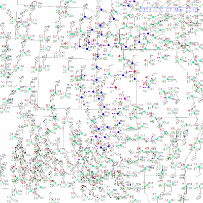
You can easily see where the center of circulation is located by looking at the wind barbs. The low is just about over southwest Missouri.

Friday, March 26, 2010
Tornadoes Across The South
The weather was active on Thursday across portions of the south as a line of thunderstorms pressed through.
A possible tornado caused some damage in the vicinity of Nashville, TN.
There were 2 confirmed tornadoes in Alabama that caused a little damage - one near Huntsville and the other near Birmingham.
But all in all, it is nothing like things could and really should be for this time in March. So be thankful! I know my family in Arkansas is glad the year has been so quiet.
Here in the central Rockies we are watching a new storm system enter the region. This one originally looked like it could slam the Denver area with another foot of snow - but now it appears the heavier snow will be west, south and east of the city - with only 2-5 inches across most of the metropolitan area.
More wet weather is in the forecat to round out March for the northeast state. Can you believe places from New Jersey to Maine have seen 10 inches of rain already this month - much of that falling just in the past 2 weeks!!
Thursday, March 25, 2010
Quiet March In Terms Of Severe Weather
I saw a great segment on The Weather Channel the other day. They were talking about how we have only seen 14 tornadoes so far this March when the average should be several dozen.
Some of this could be related to how cold the winter has been - including across the Gulf of Mexico - where temperatures are way below average.
Watch the video in this link for more...
Video: Where are the storms?
Some of this could be related to how cold the winter has been - including across the Gulf of Mexico - where temperatures are way below average.
Watch the video in this link for more...
Video: Where are the storms?
Tuesday, March 23, 2010
Thundersnow Conitnues
Nearly 2 hours now with off and on rolls of thunder in southeast Aurora! WOW - incredible. The snowfall rates are 2 to 3 inches per hour. It is really piling up - already covering the sidewalks, driveway and the streets.
Thundersnow always comes with intense snowfall rates - in some cases it can be 5 inches per hour! I just saw a report near Evergreen in the foothills of 5.5 inches of snow in 90 minutes.
Look at the line of storms east of Denver!

Thundersnow always comes with intense snowfall rates - in some cases it can be 5 inches per hour! I just saw a report near Evergreen in the foothills of 5.5 inches of snow in 90 minutes.
Look at the line of storms east of Denver!

Thunderstorms With Snow - Yes, I Said Snow
Well today was a day that all meteorologists in Colorado live for - the weather has gone from spring to winter in no time flat.
In fact, as I sit and type this blog at roughly 5:30 pm, I am listening to soft rumbles of thunder and watching snow fall so hard and fast that I cannot see the interstate just behind my home.
On my drive from Boulder to southeast Aurora this afternoon I went from temperatures near 50 degrees and a mix of sun and clouds - to thunderstorms with sleet, graupel and snow.
Some call graupel - hail - and for the common man it is the same because both are seen from the ground as ice falling from the sky. But for a meteorologist - there is a difference between hail and graupel because of how each is formed.
The center of a hailstone is actually a super cooled water droplet that is carried up and down by the wind currents within a thunderstorm cloud. The longer it is suspended in the cloud the larger it grows. The ice is usually hard. Once the weight of the hailstone overcomes the forces of the wind keeping it suspended, it falls to the Earth.
The center of graupel is actually a snowflake in which super cooled water droplets condense on the flake. The ice is much softer than hail. We usually see graupel during winter storms that have a lot of dynamics going on in the upper atmosphere - such as with the dramatic spring weather - where we see the drastic change from nice weather to rain to snow - all within a few hours or less.
You typically will not see graupel during winter storms that happen in the middle of winter when conditions aren't so dynamic.
I wish you could see the rate of this snow - if this was to keep up all night - we will easily be shoveling at least 10 inches - but more like 20 inches of snow from the area driveways and roads.
Something tells me this isn't going to quite be the March 2003 blizzard - but it will be one of the more memorable storms this season - just a gut feeling!
Tsunami Awareness Week
It's the first ever tsunami awareness week in the United States. There is a lot of great information to read...especially if you live near a coast or frequent a coastal area often.
Click this link to read more.
Meanwhile, here in the central Rockies, we are bracing for another spring snowstorm. Not at all uncommon this time of year for the Denver area to see a heavy, wet 10 to 20 inches of snow.
We'll know about this time tomorrow if everything comes together to produce that much of the white stuff!!
Monday, March 22, 2010
Prescribed Burns May Help Reduce U.S. Carbon Footprint
The following is courtesy of NCAR.
The use of prescribed burns to manage Western forests may help
the United States reduce its carbon footprint. A new study finds that
such burns, often used by forest managers to reduce underbrush and
protect bigger trees, release substantially less carbon dioxide
emissions than wildfires of the same size.
"It appears that prescribed burns can be an important piece of a climate
change strategy," says Christine Wiedinmyer, a scientist with the
National Center for Atmospheric Research (NCAR) and lead author of the
new study. "If we reintroduce fires into our ecosystems, we may be able
to protect larger trees and significantly reduce the amount of carbon
released into the atmosphere by major wildfires."
The study is being published this week in Environmental Science and
Technology. It was funded by the National Science Foundation, NCAR's
sponsor.
Drawing on satellite observations and computer models of emissions, the
researchers concluded that widespread prescribed burns can reduce fire
emissions of carbon dioxide in the West by an average of 18 to 25
percent, and by as much as 60 percent in certain forest systems.
Wildfires often destroy large trees that store significant amounts of
carbon. Prescribed fires are designed to burn underbrush and small
trees, which store less carbon. By clearing out the underbrush, these
controlled burns reduce the chances of subsequent high-severity
wildfires, thereby protecting large trees and keeping more carbon locked
up in the forest.
"When fire comes more frequently, it's less severe and causes lower tree
mortality," says Matthew Hurteau of Northern Arizona University, the
study's co-author. "Fire protects trees by clearing out the fuel that
builds up in the forest."
-----The importance of trees-----
Forests have emerged as important factors in climate change. Trees
store, or sequester, significant amounts of carbon, thereby helping
offset the large amounts of carbon dioxide emitted by factories, motor
vehicles, and other sources. When trees burn down or die, much of that
carbon is returned to the atmosphere. It can take decades for forest
regrowth to sequester the amount of carbon emitted in a single fire.
In the western United States, land managers for more than a century have
focused on suppressing fires, which has led to comparatively dense
forests that store large amounts of carbon. But these forests have
become overgrown and vulnerable to large fires. Changes in climate,
including hotter and drier weather in summer, are expected to spur
increasingly large fires in the future.
This could complicate U.S. efforts to comply with agreements on reducing
carbon emissions. Such agreements rely, in part, on forest carbon
accounting methodologies that call for trees to store carbon for long
periods of time. Large carbon releases from wildland fires over the next
several decades could influence global climate as well as agreements to
reduce emissions.
To determine whether prescribed burns would likely affect the carbon
balance, the scientists first estimated actual carbon emissions from
fires for 11 Western states from 2001 to 2008. They used satellite
observations of fires and a sophisticated computer model, developed by
Wiedinmyer, that estimates carbon dioxide emissions based on the mass of
vegetation burned.
Their next step was to estimate the extent of carbon emissions if
Western forests, during the same time period, had been subjected to a
comprehensive program of prescribed burns. The scientists used maps of
vegetation types, focusing on the forest types that are subject to
frequent natural fires and, therefore, would be top candidates for
prescribed burns. Emissions in the model were based on observations of
emissions from prescribed burns of specific types of forests.
The results showed that carbon emissions were reduced by anywhere from
37 to 63 percent for the forests that had been subject to prescribed
burns, depending on the vegetation mix and location of the forests.
Overall, carbon emissions for the 11 Western states were reduced by an
annual average of 14 million metric tons. That is the equivalent of
about 0.25 percent of annual U.S. carbon dioxide emissions, or slightly
more than the annual carbon dioxide emissions from all fossil fuel
sources in some less-populated states, such as Rhode Island or South Dakota.
The authors cautioned, however, that the actual impacts in the Western
states would likely be lower. Their study assumed that prescribed burns
could be set in all suitable forests, whereas forest managers in reality
would be hard-pressed to set so many fires, especially in remote regions
or near developments.
New Mexico had the highest average annual reduction (35 percent) because
of its forest types, followed by Montana, Arizona, California, and
Colorado.
The study notes that prescribed burns could lead to additional air
quality benefits. Previous research has indicated that such burns could
reduce emissions of pollutants such as fine particulate matter and
carbon monoxide.
"While it can be costly to set controlled fires, there is also a cost in
leaving forests vulnerable to larger fires," Wiedinmyer says. "More
research can help forest managers make better decisions about our
forests and climate change."
The University Corporation for Atmospheric Research manages the National
Center for Atmospheric Research under sponsorship by the National
Science Foundation. Any opinions, findings and conclusions, or
recommendations expressed in this publication are those of the author(s)
and do not necessarily reflect the views of the National Science
Foundation.
Thursday, March 18, 2010
Spring To Winter In 24 Hours
If you have never been in Denver during the spring, and you love the weather, well.....hurry and get here in the next 12 hours is all I gotta say!
We are about to get one of our famous 40 degree temperature drops with up to a foot of snow on strong, gusty winds.
It was in the 70s on Wednesday. Today we are only expecting mid to upper 60s due to the increasing cloud cover ahead of the cold front.
By midnight tonight, the winds should be screaming from a northerly direction with a drastic chill in the air. Snow will develop overnight. Initially there could be a few rain showers - and who knows - maybe a clap of thunder somewhere.
Our high temperature for Friday should happen at midnight with daytime temps on Friday only in the 20s. Moderate to heavy snow is anticipated.
We will start to recover on Saturday with late day clearing and highs in the 30s.
Wednesday, March 17, 2010
Flood Safety Awareness Week
It is National Flood Safety Awareness Week in the United States - and below is a great link with all kinds of resources for you to learn more about this important topic.
More On Flood Safety Awareness
Our friends in the upper midwest, specifically North Dakota and Minnesota, know all too well about flood safety. Many people in this region, especially along the Red River, are in a tense fight to hold the flood waters back.
Levels in Fargo and Grand Forks are already in the major flood category and are too close to the record marks.
Outside of the upper midwest, there are plenty of other areas at risk for flooding this spring due to the very snowy winter - including portions of the east and south.
Click here to read more on the spring outlook.
Portions of the northeast are dealing with flooding concerns from the heavy rains received this past weekend - up to 6 inches in some communities. A widespread 3-6 inches of rain fell across much of Connecticut, New Jersey, southeast New York and Mass. this past weekend.
The western states are not expecting any significant flood threats other than from flash floods as we move into the summer thunderstorm season.
Tuesday, March 16, 2010
Monday, March 15, 2010
The Week Ahead
Well let's start off with some positive news for our friends in the northeast who were hammered with heavy rain and high winds over the weekend.
If you can make it through today - there is good news ahead. Not only will it dry out for much of the upcoming week, but the winds will subside AND the temperatures will warm up significantly - we are talking 60s in many areas by mid-week.
In the upper midwest all eyes are on area rivers as the snow melt continues and water levels rise. Along the Red River in North Dakota and Minnesota, some communities are already seeing levels reach minor flood stage - with several more days of melting ahead, residents are hoping Mother Nature doesn't add insult to injury with any new storm systems.
Temperatures in the mid-south will approach 70 degrees this week before a storm system moves in over the upcoming weekend and cools things back into the 50s. There could be some thunderstorms too - so keep an eye on the forecast.
The pick weather spot of the week looks like the deserts of the southwest US - expect sunny skies all week from Phoenix to LA to Vegas with highs near 80 degrees in all 3 cities.
Saturday, March 13, 2010
Tropical Storm Force Winds Hit Northeast
What a raw day in the Big Apple!
Winds for the last two hours have been sustained at 44 to 46 mph with gusts 64-66 mph at JFK Airport. Temperatures are holding in the lower 40s with rain and fog.
It's not much better over at La Guardia or Central Park.
Much of the New England and mid-Atlantic areas are experiencing very unsettled weather. There have been numerous trees downs, traffic accidents and reports of flooding.
In West Virginia, there has even been 1 confirmed death due to flood waters and at last report there was a firefighter missing.
The cause of the winds is a squeeze play between high pressure over southeast Canada and developing low pressure over Virginia.
The lines of equal pressure, or isobars, are what we call in the weather world "tightly packed" - when you see this you can bet there is a TON of wind across the pressure gradient.
And the winds will blow until the atmosphere equals itself out and the pressure becomes more balanced. At 6:30 pm eastern, the pressure in Washington DC was 29.34" and in Bangor, Maine it was 30.30" - that is a HUGE difference!


Friday, March 12, 2010
Flooding Rains Expected This Weekend In New England
A slow moving coastal storm is expected to bring 3 to 6 inches of rain to coastal New England this weekend, including Long Island and the New York City metro area.
Meanwhile, we are getting ready for a wonderful teaser to spring here in the Denver area with highs today and tomorrow near 60 degrees!
Looking ahead to next weekend, there could be a big winter storm moving into the lower 48 with heavy mountain snow in the Rockies and severe thunderstorms out ahead of it in the central states.
It's spring time!! (well almost - next weekend)
Be sure to SPRING FORWARD this weekend on your clock - the time changes this Sunday.
Thursday, March 11, 2010
Tornadoes Sweep Across Arkansas, Claims 1 Life
The first severe weather outbreak of the year hit the mid-south on Wednesday, producing at least 4 tornadoes across the state of Arkansas.
Storms raced northeast along a squall line - with the first tornado touching down briefly in southwest Arkansas.
The next touchdown was in the southwest suburbs of Saline County near Benton.
Here is home video of that tornado.
As you can see in the video linked above - there are a ton of trees in the way and the view of the tornado isn't the best.
That is why storm chasers don't often venture into this part of the world, known as the "jungles" in storm chaser lingo.
In Texas, Oklahoma, Kansas, Nebraska, South and North Dakota, eastern Wyoming and Colorado, it is a different story. You can see for miles and miles - making storm chasing much easier and safer.
The storms then continued across the Little Rock area and produced 2 more tornadoes on the extreme northeast side of the metro area. One in White County just west of Searcy and the other in Cleburne County near Quitman and Heber Springs in the town of Pearson.
The tornado in Cleburne County caused 3 serious injuries and claimed one life. All the tornadoes did damage to homes in the touchdown vicinity.
The Saline County tornado struck around 6:30 pm. The White and Cleburne County tornadoes struck between 8:30 and 9:15 pm.
Nighttime tornadoes are dangerous because you simply cannot see what is coming unless the twister is illuminated in between lightning flashes.
Wednesday, March 10, 2010
Severe Weather Outbreak Possible Today
There have been a few stray thunderstorms this year, some severe - such as the tornado producing storm on Monday in Oklahoma.
But today may be the first "outbreak" of severe weather - meaning storms that cross over a wide swath of real estate and produce several damage reports.
A watch has already been issued for north central Texas, including the Dallas area. This will shift east and slightly northeast as the day progresses. Eastern Oklahoma and Arkansas look to be in the target zone, although southern Missouri and extreme southeast Kansas may also see some rough weather.

Tuesday, March 9, 2010
Severe Weather Season Kicks Off
Several storm chasers were in the thick of things on Monday as severe weather season kicked off in tornado alley with a bang.
Ground zero was in Roger Mills County, Oklahoma, with a tornado on the ground for about a half hour.
Initially the twister developed just northwest of Elk City, which is along Interstate 40 in extreme western Oklahoma.
The storm then tracked northeast, moving through the southern portion of Hammon, a small town with a population around 500.
The county barn and 4 homes were destroyed with some damage reported to other structures.
More severe weather is possible today in the mid-south, with an even larger outbreak possible on Wednesday.
WET DAYS AHEAD
Two storm systems tracking across the nation are expected to deliver a wet period to much of the lower 48 states.
Below is a map for forecasted total precipitation between now and the upcoming weekend.
The bullseye looks to be around the New York City area, north Florida, and along the extreme northwest coastline of the US.

Sunday, March 7, 2010
Australia Hit Hard By Severe Storms
Severe thunderstorms roared across portions of Australia over the weekend with heavy rain and large, damaging hail.
One report said as many as 40,000 insurance claims were expected after the storm damage.
Rural communities of Queensland were dealing with rising flood waters after days of heavy rain. The Balonne River in St. George was expected to peak Saturday or Sunday at 44 feet - its highest level since records began in 1890.
In Melbourne, heavy rain and large hail caused the delay of sporting events, shut down transportation and even forced the evacuation of a train station when the storm tore a hole in its roof.
Here in the states we may see some heavy rain this week across portions of the central plains and the south. There could even be a few thunderstorms Monday and Tuesday - but at this time - it doesn't look like a severe weather outbreak.
Now that could change as we head into Wednesday and more "ingredients" come together across the Ark-la-tex. (that is short for Arkansas, Louisiana and Texas)
Friday, March 5, 2010
Few Storms Today Across High Plains
A disturbance is moving across Colorado this morning - making for a very foggy start to Friday along the Front Range. We may see a few rain or snow showers out of it.
As the weather system moves out into the central plains states today, there could be a few strong thunderstorms across Kansas or Nebraska.
Not a big deal - just more of a reminder of the days that lie ahead.
Speaking of thunderstorms, I saw an analysis on The Weather Channel last night regarding the frequency of thunderstorms that produce tornadoes in El Nino years. 6 out of 9 had higher than normal tornadoes.
So we could potentially be in for an active year if statistics hold true.
Here is a link to that report I saw last night.
Around the world it has been a very active weather week - with everything from flooding rains in South America to high waves in the Middle East.
Check out this video of a 33 foot wave hitting a cruise ship on the Mediterranean Sea. The wave killed 2, injured over a dozen and caused damage to the passenger ship.
And finally, 2010 has been quite the year so far in terms of weather records. Everything from record setting rain in Las Vegas and Phoenix to snow in Washington DC, Baltimore and Philadelphia.
Even places in the south have seen either record setting snows or top 5 snows, such as Atlanta and Dallas.
Here is a nice summary of the most recent snow in Atlanta and how they rank thus far in the record books.
Thursday, March 4, 2010
Weather Patterns Turning Spring-Like
Well it's that time of the year - the weather patterns are starting to show characteristics of spring.
Let's start with the US snow cover - it is slowly but surely eroding and heading north - see the map below.
The prolonged snow cover this year has kept much of the nation locked into below normal temperatures. In fact, I heard a weather statistic yesterday that February had no tornadoes recorded in the United States - the first time this has happened since 1947.

With the rising sun angle, longer days ahead, and no snow cover across the southern tier of states - we will start seeing a larger contrast between the air masses as you travel north to south.
This will set the stage for spring storm systems that bring snow and cold on the north side and west side with thunderstorms and warm, humid air on the south and east side.
Get ready for an active week to 10 days ahead as a series of storm systems move along the jet stream across the center of the nation. Below is a map outlining a few of the larger threats we will face in the next 10 days.

Tuesday, March 2, 2010
Radar Review
In the last blog I mentioned the storm in New England, and how there was a rain/snow line that almost followed the eastern border of NewYork state - well one of our very loyal CoCoRaHS observers and my good blog friend, Josh Herman, produced a radar loop of that storm so you can see what I was talking about.
Click here to view.
It will open as a movie and is probably best viewed on Quicktime Player.
Click here to view.
It will open as a movie and is probably best viewed on Quicktime Player.
Subscribe to:
Posts (Atom)